
Sykes Avenue - Gettysburg National Military Park Historic District - Gettysburg, PA
N 39° 47.431 W 077° 14.197
18S E 308492 N 4406899
Every major road & lane are deemed contributing structures because they were constructed at the initial formation of the park to allow visitors to access even the most remotest part of the battlefield in a safe and easy manner. Such is Sykes Avenue.
Waymark Code: WME5Z2
Location: Pennsylvania, United States
Date Posted: 04/07/2012
Views: 8

Sykes Avenue is named after Union General George Sykes, commander of the Fifth Corps. Sykes Avenue begins at the intersection of Confederate Avenue, Warren Avenue and Wright Avenue, and runs north over the east flank of Little Round Top to the intersection with Wheatfield Road, where it continues north as Sedgwick Avenue. It is a one way road going north. Union monuments cluster thickly around this strategic hill, a turning point of the battle. It also affords a magnificent overlook of the southern part of the battlefield which can be particularly lovely at sunset.
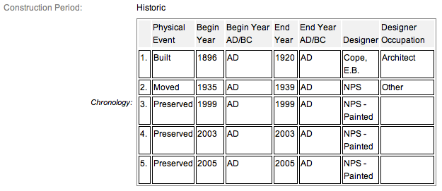
The avenue measures 0.138 miles long by 20' wide and is constructed of bituminous treated macadam with a telford base. The Altered portion includes 10' wide by 600' long dirt covered asphalt trace from woods S of Ave & ends at intersection of Sykes & Wheatfield Road. The road was realigned by the NPS in 1935-38. The road was constructed by the War Department to follow positions defended by 5th Corps under command of General Sykes. Sykes Avenue only permits one-way traffic heading north. There are gates near the terminus with the Wheatfield Road that are used to close the road to vehicular traffic during periods of ice and snow in the winter.
Parking can be an issue at peak times, in spite of a large number of spaces at Little Round Top summit. A small number of parking spaces are also available on Wright and Warren Avenue at the foot of the hill.
Sykes Avenue is a contributing feature to the Gettysburg National Military Park Historic District which is nationally significant under NR Criteria A, B, C & D. Areas of Significance: Military, Politics/Government, Landscape Architecture, Conservation, Archeology-Historic. Period of Significance: 1863-1938. The original National Register Nomination was approved by the Keeper March 19, 1975. An update to this nomination was approved by the Keeper on January 23, 2004. This roadside marker is listed as contributing structure number RD362.
From the nomination form
Constructed by War Department to follow positions defended by 5th Corps under command of General Sykes. Located on Little Round Top & extends from Wheatfield Road to Warren Avenue. Constructed to make Little Round Top accessible to tourists.
Short Physical Description:
Avenue measures 0.138 miles long by 20' wide. Constructed of bituminous treated macadam with telford base. Altered portion includes 10' wide by 600' long dirt covered asphalt trace from woods S of Ave & ends at intersection of Sykes & Wheatfield Road. Realigned by NPS in 1935-38.
Long Physical Description:
Designed by E.B. Cope, this circulation feature was one several circulation structures that were developed between 1882 and 1920 along the battle lines of the Union and Confederate armies or to connect those battle lines. They were principally laid out as 60-foot wide corridors that included the roadway itself, the monumentation, formal park grounds, and enclosure fencing.
My Sources
1.
NRHP Narrative
2.
Stone Sentinels
3.
Draw the Sword