
Hood’s Division served as a member of the Longstreet’s Corps in the Army of Northern Virginia. Maj. Gen. John Bell Hood (June 29, 1831 – August 30, 1879) was a Confederate general during the American Civil War. Hood had a reputation for bravery and aggressiveness that sometimes bordered on recklessness. Arguably one of the best brigade and division commanders in the Confederate States Army, Hood became increasingly ineffective as he was promoted to lead larger, independent commands late in the war, and his career was marred by his decisive defeats leading an army in the Atlanta Campaign and the Franklin-Nashville Campaign.
The Hood's CS Division Tablet is located on the west or right side South Confederate Avenue if traveling south, a few steps way from the Texas State Monument. The marker is located at the very top of the handle of a large 'soup ladle' of a turn, at least that is what is looks like on a map. 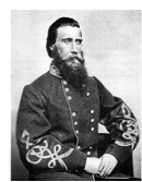 Just .32 miles away is where South Confederate Avenue curves in a wide arc then repeats itself and curves again in the opposite direction just like a sine wave. The memorial faces due east and is located very close to the road, however, parky is tricky around here so exercise caution. Please do not park on the grass, park on the side of the road. I cannot emphasize that enough! I visited this monument on Saturday, March 10, 2012 at 4:36 PM, just before the clocks were set ahead for the Spring. I was at a 632 foot ASL elevation.
Draw the Sword, with descriptive help from the NPS site, offers the following description: One of ten Confederate division monuments that describe the movements and itenirary of each division of the Army of Northern Virginia. Designed by E. B. Cope. The locations of the markers indicate the general location of the battle lines of the various Confederate divisions during the battle.
Monument is a rock-faced granite monolith with polished face on which is affixed a bronze narrative tablet. Dimensions: 4.2 feet x 2.0 feet, with an overall height of 7.0 feet. The tablet was erected on July 1, 1907 by the Gettysburg National Military Park Commission. The inscription on this monolith reads:

Army of Northern Virginia
First Army Corps
Hood's Division Maj Gen. J.B. Hood, Brig. Gen. E.M. Law
Law's Brigade Brig Gen. E.M. Law, Col. James L. Sheffield
Robertson's Brigade Brig. Gen. J.B. Robertson
Anderson's Brigade Brig. Gen. George T. Anderson, Lieut. Col. William Luffman
Benning's Brigade Brig. Gen. Henry L. Benning
Artillery Battalion Four Batteries Major M.W. Henry
July 1 On the march to Gettysburg. Encamped about four miles from field with the exception of Law's Brigade left on picket at New Guilford.
July 2 Law's Brigade joined from New Guilford about noon. The Division was formed on extreme right of the Army and directed to drive in and envelope the Union left. About 4 p.m. the Batteries opened and soon after the Division moved forward. After a severe struggle the Union line retired to the ridge in rear. The ground fought over was obstructed by stone fences and very difficult. The movement was partially successful the battle continuing until nearly dark. The advance gained was held.
July 3 Occupied the ground gained and with the exception of resisting a Cavalry charge and heavy skirmishing was not engaged.
July 4 The Division took up the line of march during the night.
Casualties killed 343 wounded 1504 missing 442 total 2289.
There are nine different variations of similar monuments (not including the inverted canons which signal headquarters) for the various Confederate States & Union brigades/batteries/divisions which fought at Gettysburg. Four designs represent brigade, division, corps and army headquarters, and each has elements which identify it as Union or Confederate. Many of the tablets were created by Albert Russell & Sons Co. of Newburyport, Massachusetts and are made of granite, bronze and concrete. Some are made of all iron (position tablets). All of these tablets were designed by architect E.B. Cope. He designed pretty much every tablet for both the Union and Confederate armies, each one distinct, with several different varieties. The monuments were erected just after the turn of the century during the first and beginning of the second decade of the 20th century. Each one has since been preserved or restored at least twice since the turn of the 21st century. The plaques and tablets were erected by the War Department and then, in later years, by the Gettysburg Battlefield Commission, which was created and then assumed responsibility for the park in the early 20th century.
On October 1, 1898, the Gettysburg National Military Park Commission in a letter to the Secretary of War set gave recommendations for continuing the task of organizing and progressing the work of the Gettysburg National Military Park. The following is an excerpt from that report relevant to this waymark. The link at the end of the paragraph will take you to the entire report. The method of marking the positions of troops on this field, as approved by the War Department, is to place the principal tablet or monument of each command at the position occupied by the command in the main line of battle, and to mark the several important positions subsequently reached by each command in the course of the battle by subordinate and ancillary tablets, with appropriate brief inscriptions giving interesting details and occurrences and noting the day and hour as nearly as possible. SOURCE
Information about these specific types of monuments:
DIVISION HEADQUARTERS MARKER
Division headquarters are rectangular bronze tablets mounted on large, rectangular stones. Union headquarters have a corps or service branch symbol (like a cross, clover or crescent moon) as a separate bronze piece above the tablet, while Confederate headquarters are labeled "C.S.A." on a separate bronze piece in an oval. There are 22 Union and 10 Confederate Division markers at Gettysburg. Both markers are of similar design and were all construed of Winnsboro (S.C.), granite. Each stands seven feet in height. SOURCE & SOURCE
The Hood's Division - CS Division Tablet is a contributing feature to the Gettysburg National Military Park Historic District which is nationally significant under NR Criteria A, B, C & D. Areas of Significance: Military, Politics/Government, Landscape Architecture, Conservation, Archeology-Historic. Period of Significance: 1863-1938. The original National Register Nomination was approved by the Keeper March 19, 1975. An update to this nomination was approved by the Keeper on January 23, 2004. The tablet is designated as contributing structure number MN757.
From the nomination form:
1 of 10 CS Division Tablets in Park. Marks the command position of Pickett's Division during Battle of Gettysburg, July 1-3, 1863. Located on W side of South Confederate Ave, near junction and S of Emmitsburg Rd.
Short Physical Description:
Rough-hewn monolith, 4'2"x2', 7' high. Bronze inscription tablet, 3'8"x3'6", mounted on polished face. Bronze oval plate inscribed "C.S.A." in raised letters.
Long Physical Description:
These 10 monuments consist of a rock-faced granite monolith with polished face on which is affixed a bronze narrative tablet. The locations of the markers indicate the general location of the battle lines of the various Confederate divisions during the battle. Designed by E. B. Cope. 4.2 feet x 2.0 feet, with an overall height of 7.0 feet.

My Sources
1.
NRHP Narrative
2.
Stone Sentinels
3.
Virtual Gettysburg
4.
Draw the Sword
5.
Historical Marker Database
6.
Wikipedia