
Ultimately, (following the top level of the chain of command) this unit fell under the command of Maj. Mathias Winston Henry (Nov. 28, 1838-Nov. 28, 1877). Henry’s Battalion served as a member of Hood’s Division in the First Corps, Army of Northern Virginia. This specific unit, however, was commanded by Captain William K. Bachman. Bachman was the son of the prominent pastor of Charleston's St John's Lutheran Church, Dr. John Bachman. The unit was formed in 1862. The unit was also known as the German Light Artillery and as the Charleston Artillery Battery. It was armed with four 12-lb. Napoleons from August 1862 to July 1863. On May 3, 1864, it was armed with two 3+" Blakely Rifles and two 12-lb. Howitzers. On January 6, 1865, if was armed with four 12-lb. Napoleons. It was surrendered by Gen. Joseph E. Johnston at Durham Station, Orange County, North Carolina on April 26, 1865. SOURCE
The marker, also known as the Bachman's German Artillery Tablet, is located on the east or left side South Confederate Avenue if traveling south. The marker is located at the very top of the handle of a large 'soup ladle' turn, at least that is what is looks like on a map. It is here where S. Confederate Avenue curves in a wide arc then repeats itself and curves again in the opposite direction just like a sine wave. There are two cannon pads, one to the right and one to the left of the monument but the cannons has been removed. There are several other similar type markers near this one also with empty cannon pads. I'd wager they are being cleaned or perhaps they were moved elsewhere. Those cannons would have represented the artillery used here during the Battle, 4 Napoleons. In the background I could see the Bushman Farm Area/Field and Little Round Top, all to the east.
The tablet faces due west. The tablet is located 26 feet from the road. Parking is tricky around here so exercise caution. Please do not park on the grass, park on the side of the road. I cannot emphasize that enough! I visited this monument on March 10, 2012 at 4:40 PM, just before the clocks were set ahead for the Spring. I was at a 625 foot ASL elevation.
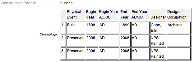
These monuments were first built in 1900 and concluded in 1906 according to the NRHP nomination form. One site has the monument being erected in 1910. It is amazing with all the work and effort exerted to make the Gettysburg National Military Park a reality, no one took the time to keep accurate records and correct installation dates. The work was done under the direction of the Gettysburg National Military Park Commission. The inscription on this tablet reads:
Army of Northern Virginia
Longstreet's Corps Hood's Division
Henry's Battalion Bachman's Battery
The German Artillery
Four Napoleons
July 2 In reserve near here but not engaged.
July 3 In position here and actively engaged in firing upon the Union lines within range. About 5 p.m. aided in repelling cavalry under Brig. Gen. Farnsworth which had charged into the valley between this point and Round Top.
July 4 Occupied position near by and west of this until 6 p.m. Then withdrew from the field.
Losses not reported in detail.
There are scores of similar monuments for the various Confederate States & Union units which fought at Gettysburg. Four designs represent brigade, division, corps and army headquarters, and each has elements which identify it as Union or Confederate. Many of the tablets were created by Albert Russell & Sons Co. of Newburyport, Massachusetts and are made of granite, bronze and concrete or like this one, cast iron. All of these tablets were designed by architect E.B. Cope. He designed pretty much every tablet for both the Union and Confederate armies, each one distinct, with several different varieties. The monuments were erected just after the turn of the century during the first and beginning of the second decade of the 20th century. Each one has since been preserved or restored at least twice since the turn of the 21st century. The plaques and tablets were erected by the War Department and then, in later years, by the Gettysburg Battlefield Commission, which was created and then assumed responsibility for the park in the early 20th century.
On October 1, 1898, the Gettysburg National Military Park Commission in a letter to the Secretary of War set gave recommendations for continuing the task of organizing and progressing the work of the Gettysburg National Military Park. The following is an excerpt from that report relevant to this waymark. The link at the end of the paragraph will take you to the entire report. The method of marking the positions of troops on this field, as approved by the War Department, is to place the principal tablet or monument of each command at the position occupied by the command in the main line of battle, and to mark the several important positions subsequently reached by each command in the course of the battle by subordinate and ancillary tablets, with appropriate brief inscriptions giving interesting details and occurrences and noting the day and hour as nearly as possible. SOURCE
Information about these specific types of monuments:
CONFEDERATE BATTERY AND BRIGADE TABLETS (ADVANCED POSITION)
These tablets are 3’8" x 3’4" in dimensions, with carefully prepared inscriptions cast in raised letters painted in white (contrasting the black background) describing the part taken in the battle by each brigade, their position and stating its numbers and losses so far as practicable to obtain. They are mounted on iron pillars or fluted cast iron posts about 3 feet high, grouted in the ground, and the tablets are inclined at a suitable angle so that the inscriptions can easily be read by persons riding or driving on the avenue. Every tablet is 4’4" in height. The advance position markers were cast by Calvin Gilbert. SOURCE & SOURCE
The Bachman's German Artillery - CS Battery Marker is a contributing feature to the Gettysburg National Military Park Historic District which is nationally significant under NR Criteria A, B, C & D. Areas of Significance: Military, Politics/Government, Landscape Architecture, Conservation, Archeology-Historic. Period of Significance: 1863-1938. The original National Register Nomination was approved by the Keeper March 19, 1975. An update to this nomination was approved by the Keeper on January 23, 2004. The monument is identified as structure number MN597-B.
From the Nomination Form:
1 of 100 Civil War tablets that locate the positions of batteries and brigades not otherwise marked by monumentation. Marks position of Bachman's CS Battery on July 2-4, 1863. Narrates events associated w/ Battery during Battle. On E side of S Confederate Ave.
Short Physical Description:
Mn w/2 flanking cannons on N and S side of mn. Cast iron tablet (3'8" x 3'4") w/raised inscriptions painted in a contrasting color and mounted on fluted cast iron posts. All 4'4" H.
Long Physical Description:
Only cannon pads remain in this location.
My Sources
1.
NRHP Nomination Form
2.
Stone Sentinels
3.
Virtual Gettysburg
4.
Draw the Sword
5.
Historical Marker Database