
2nd U.S. Missouri Infantry Regiment Marker - Chickamauga National Military Park
Posted by:  Lat34North
N 34° 54.824 W 085° 16.046
16S E 658273 N 3864846
This marker to the 2nd U.S. Missouri Infantry Regiment is located on the west side of Glen-Kelley road, west of the creek that runs through Dyer Field in the Chickamauga National Military Park.
Waymark Code: WMDWK6
Location: Georgia, United States
Date Posted: 03/02/2012
Views: 1
This marker for
2nd Missouri Volunteer Infantry is in recognition of their service during the
Battle of Chickamauga, fought September 19–20, 1863. This is the only marker to the 2nd Missouri Infantry on the battlefield. The 2nd Missouri Infantry was organized at St. Louis, Missouri, and mustered into Federal service on September 10, 1861.
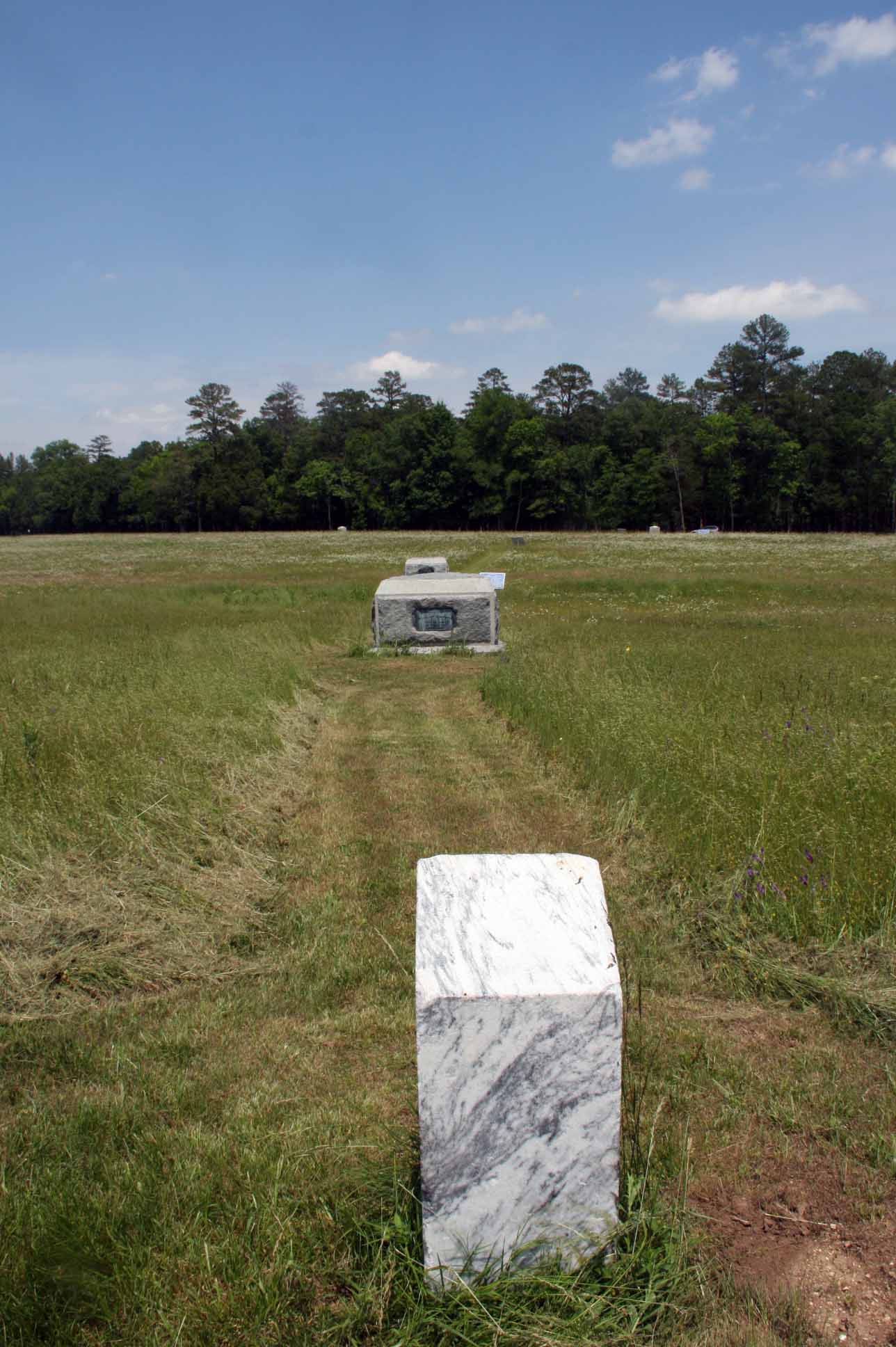
This marker indicates the unit's position during the battle, September 19-20, 1863.
2nd Missouri Infantry,
Commanded by; Maj. Arnold Beck.
Second Brigade, Col. Bernard Laiboldt. - Third Division. Maj. Gen. Philip H. Sheridan. - XX Army Corps. Maj. Gen. Alexander McD. McCook
From the NRHP nomination form:
| |
Structure Number: |
MT-906(see note) |
| |
LCS ID: |
003220 |
Historical Significance:
| |
National Register Status:
|
Entered - Documented
|
| |
National Register Date:
|
11/24/1998
|
| |
National Historic Landmark?: |
No
|
| |
Significance Level:
|
Contributing
|
| |
Short Significance Description:
|
The marker contributes to the national significance of the park under NR Criterion A because it represents the national movement among veterans to commemorate Civil War battlefields. This was the first U.S. national military park.
|
Short Physical Description
A simple 15" x 15" x 3' marble shaft with a slanting inscribed top marking unit's position during the battle, September 19-20, 1863.
Long Physical Description
Monument located within the Chickamauga Battlefield in South Dyer Field, map site #187.
Material(s)
|
|
Structural Component(s)
|
Material(s)
|
1.
|
Superstructure
|
Marble
|
|
Construction Period:
|
Historic
|
Chronology:
|
|
Physical Event
|
Begin Year
|
Begin Year AD/BC
|
End Year
|
End Year AD/BC
|
Designer
|
Designer Occupation
|
1.
|
Built
|
1895
|
AD
|
|
|
|
|
|
My Sources
1.
NRHP
2. Wikipedia -
Battle of Chickamauga
3. The Civil War Home -
The Chickamauga Campaign - Union Order of Battle
4. Wikipedia -
2nd Missouri Volunteer Infantry
Note
Trailhead Graphics, Inc. has produced a map of the Chickamauga Battlefield showing the locations of all of the monuments and the markers on the battlefield. Each location on the map has a number associated with it that cross-references to an index on the back of the map that has the name of the marker (called the Chick-Chatt NMP monument numbering system). This number corresponds to the structure Number listed on the NPS List of Classified Structures that is normally prefixed with the letters MT for the Chickamauga Battlefield.