
The monument is also known as the Battery C, Fifth U.S. Artillery Tablet. The marker is located on the right or east side of the Hagerstown Pike/Dunker Church Road on the Miller Farm, if traveling north along the Pike. These Union tablets are included in the Antietam Campaign War Department Markers marker series. The markers are made of cast iron with a concrete sub structure. The tablets are 12 square feet, black, with white, raised letters. This tablet reads:
 U.S.A.
Battery C, 5th U.S. Artillery
Captain Dunbar R. Ransom, U.S.A. Commanding,
(September 16-17, 1862.)
On the evening of September 16th, Battery C, 5th U.S. Artillery came into battery 370 yards east of the Hagerstown Pike, on the south edge of the North Woods and opened fire upon a Confederate battery in the open field west of the Pike and north of the Dunkard Church, causing it to retire. After dark the Battery was withdrawn and bivouacked 75 yards east of J. Poffenberger's Barn.
On the morning of the 17th, the Battery advanced to a position 205 yards due east of this point and engaged the Confederate infantry which had made a lodgement in Miller's Cornfield; the Battery was supported by Anderson's and Magilton's Brigades of Meade's Division and Gordon's Brigade of the Twelfth Corps. After the repulse of the Confederate advance the Battery retired to its bivouac of the 16th.
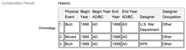
Between 1896 and 1898 to commemorate the Battle of Antietam, September 16-18, 1862, the War Department erected tablets describing Confederate and Union actions of the battle. These tablets contribute to the National Register under Criterion A and are within the period of significance, 1800-1899. The monument is classified as contributing structure number TAB-105.
From the nomination form:
In the 1880s, interest in visiting and memorializing battlefields by aging veterans was on the rise. The first indication of this increase in battlefield visits was in 1888 when a macadam road bed and sidewalk system was constructed by the War Department from the cemetery and battlefield site to the Antietam railroad station in Sharpsburg.
A Congressional Act passed in 1890 authorized dedication of the park. Field surveys of the battlefield by the War Department recorded the progression of the battle of both Union and Confederate armies, through tablets constructed in 1896-1898.
Both the Antietam National Battlefield Site and National Cemetery were transferred from the War Department to the National Park Service in 1933. In 1934, the battlefield was less than 50 acres; it has greatly increased to a present acreage of 3,199 acres. With the authorization of the 1966 National Historic Preservation Act (NHPA), the Union and Confederate War Department Tablets were listed on the National Register on October 15, 1966, with a confirmation National Register form updated and approved by the Keeper on February 10, 1982.
During the 1996 LCS survey, Determinations of Eligibility (DOE) were completed on the war tablets. This was unnecessary, as the tablets were listed on the National Register by means of the act.
Short Physical Description
Union Tablet No. 105 is a 35” x 47” cast-iron painted tablet that is 1/2" thick with a 1" raised border, which is set on a metal a 3-1/2" diameter post. A historical description of the troop’s movement is cast into the tablet.
Union Tablet No. 105 is located on the east side of Old Hagerstown Pike near the D.R. Miller House by Locational Tablet 599.
Long Physical Description
The cast text on Union Tablet No. 105 states: “U.S.A. / BATTERY C, 5TH U.S. ARTILLERY, / CAPTAIN DUNBAR R. RANSOM, U.S.A., COMMANDING./ (SEPTEMBER 16 – 17, 1862.)/ ON THE EVENING OF SEPTEMBER 16TH, BATTERY C, 5TH U.S. ARTILLERY/ CAME INTO BATTERY 370 YARDS EAST OF THE HAGERSTOWN PIKE, ON THE/ SOUTH EDGE OF THE NORTH WOODS AND OPENED FIRE UPON A CONFEDERATE/ BATTERY IN THE OPEN FIELD WEST OF THE PIKE AND NORTH OF THE DUNKARD/ CHURCH, CAUSING IT TO RETIRE, AFTER DARK THE BATTERY WAS WITHDRAWN/ AND BIVOUACKED 75 YARDS EAST OF J. POFFENBERGER’S BARN.” “ON THE MORNING OF THE 17TH, THE BATTERY ADVANCED TO A POSITION/ 205 YARDS DUE EAST OF THIS POINT AND ENGAGED THE CONFEDERATE/ INFANTRY WHICH HAD MADE A LODGEMENT IN MILLER’S CORNFIELD; THE/ BATTERY WAS SUPPORTED BY ANDERSON’S AND MAGILTON’S BRIGADES OF/ MEADE’S DIVISION AND GORDON’S BRIGADE OF THE TWELFTH CORPS. / AFTER THE REPULSE OF THE CONFEDERATE ADVANCE THE BATTERY/ RETIRED TO ITS BIVOUAC OF THE 16TH.”
My Source
1.
NRHP Nomination Form
2.
Stone Sentinels
3.
Virtual Antietam
4.
Historical Marker Database
5.
The Battle of Antietam on the Web