Nickajack Cave
Posted by: Groundspeak Premium Member ChapterhouseInc
N 35° 01.444 W 085° 33.531
16S E 631473 N 3876661
Cave used by town in 1700s and CSA during Civil War.
Waymark Code: WMCZ4
Location: Tennessee, United States
Date Posted: 05/18/2006
Published By:Groundspeak Premium Member ChapterhouseInc
Views: 45

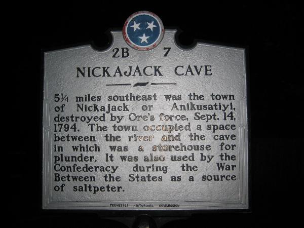
5 1/4 miles southeast was the town of Nickajack or Anikusatiyi, destroyed by Ore's force, Sept. 14, 1794. The town occupied a space between the river and the cave in which was a storehouse for plunder. It was also used by the Confederacy during the War Between the States as a source of saltpeter.
Marker Name: Nickajack Cave

Marker Location: Roadside

Type of Marker: Other

Group(s) Responsible for placing Marker:
Tennessee Historical Commission


Marker Number: Not listed

Visit Instructions:
At minimum, your visit must consist of a picture of the marker itself or anything referenced on the marker plus additional information you may have learned about the waymark topic. (You and your GPS receiver do not need to be in the picture, but can.)
Search for...
Geocaching.com Google Map
Google Maps
MapQuest
Bing Maps
Nearest Waymarks
Nearest Tennessee Historical Markers
Nearest Geocaches
Create a scavenger hunt using this waymark as the center point
Recent Visits/Logs:
Date Logged Log User Rating  
Go Boilers! wrote comment for Nickajack Cave 12/29/2022 Go Boilers! wrote comment for it
Jeep02 visited Nickajack Cave 04/08/2011 Jeep02 visited it
NickTnReb visited Nickajack Cave 05/08/2008 NickTnReb visited it
lilluckyclover visited Nickajack Cave 09/13/2007 lilluckyclover visited it
BackBrakeBilly visited Nickajack Cave 08/28/2007 BackBrakeBilly visited it
Better Half visited Nickajack Cave 08/28/2007 Better Half visited it
ChapterhouseInc visited Nickajack Cave 05/18/2006 ChapterhouseInc visited it

View all visits/logs