
Hancock Avenue - Gettysburg National Military Park Historic District - Gettysburg, PA
N 39° 48.986 W 077° 14.095
18S E 308709 N 4409772
Hancock Ave. has some beautiful roadside monuments on its long self. The road was constructed in the 1890s to help visitors explore remote parts of the battlefield. There are equally old iron avenue marker to identify the road for visitors.
Waymark Code: WMCXA6
Location: Pennsylvania, United States
Date Posted: 10/22/2011
Views: 9

The coordinates for this waymark are for the cast iron ID tablet identifying the road and is located at the northern most section of Hancock Avenue, just before the 'T', where it dead ends. This part of Hancock Avenue is just north of the Bryan Farm @ Ziegler's Grove. This road is named for General Winfield Scott Hancock, commander of the Second Corps.
The road is part of the War Department system of avenues designed and built to provide access to various sections of Battlefield. Hancock Avenue loops through 3rd day Battlefield including High Water Mark of Rebellion. The road follows the original route laid out by GBMA.
This north end of Hancock Avenue is densely packed with monuments. A scene of heaving fighting on July 2nd and again on July 3rd during Pickett's Charge, it includes Gen. Meade's Headquarters and equestrian statue. With the closing of the old Cyclorama and the uncertan fate of its building, it is an area in transition. (Stone Sentinels - citation below)
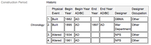
The road was first built in 1882 and altered in 1934 and 1961 probably to accommodate the growing park, which by then had turned into a national tourist attraction. The avenue originally was constructed of telford-based paving measuring 25' wide. It was widened & and then paved with bituminous asphalt in 1934 to approximately 36' wide x 1.237 mi long. The avenue begins at joining of United States Avenue and Sedgwick Avenue and loops to Cyclorama Drive. The road was altered with the construction of the Cyclorama parking lot (1961?).
Hancock Avenue is a contributing feature to the Gettysburg National Military Park Historic District which is nationally significant under NR Criteria A, B, C & D. Areas of Significance: Military, Politics/Government, Landscape Architecture, Conservation, Archeology-Historic. Period of Significance: 1863-1938. The original National Register Nomination was approved by the Keeper March 19, 1975. An update to this nomination was approved by the Keeper on January 23, 2004. This roadside marker is listed as contributing structure number RD310.
From the NRHP narrative page for this tablet:
Part of War Department system of avenues designed & built providing access to various sections of Battlefield. Hancock Avenue loops through 3rd day Battlefield including High Water Mark of Rebellion. Follows original route laid out by GBMA.
Short Physical Description:
Avenue originally constructed of telford-based paving measuring 25' wide. Widened & bituminous asphalt paved in 1934 to approx. 36' wide x 1.237 mi long. Avenue begins at joining of US Avenue & Sedgewick Ave and loops to Cyclorama Drive. Altered w/ construction of Cyclorama parking lot.
Long Physical Description:
Designed by E.B. Cope, this circulation feature was one several circulation structures that were developed between 1882 and 1920 along the battle lines of the Union and Confederate armies or to connect those battle lines. They were principally laid out as 60-foot wide corridors that included the roadway itself, the monumentation, formal park grounds, and enclosure fencing.

My Source
1.
NRHP Narrative
2.
Stone Sentinels
3.
Draw the Sword