This site is easily accessible from I-77, Exit 93, less than a mile south of the small village of Bolivar, Ohio. The grounds are administered by the Ohio State Park Department. The centerpieces is the museum operated by the Ohio State Historical Society. There are relics recovered during three major archaeological excavations, and a crypt containing the remains of soldiers uncovered during the excavations. Nearby is one tomb dedicated to an unknown soldier, and there are several other plaques.
There are no actual remains of the fort itself. In fact, it wasn't until the excavations that the true location of the fort and its buildings was discovered. But, there are outlines marking the walls and buildings of the fort with a series of interpretive signs at key locations. These are detailed below.
The hours for this park are seasonal, so check for the current schedule before making a visit. The grounds are open for walking and picnicking, and various reenactments are held here.
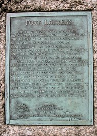
ERECTED
SEPTEMBER 21, 1928
BY THE
OHIO DAUGHTERS OF THE AMERICAN REVOLUTION
One of best accounts of the fort is from the Friends of Fort Laurens:
In early 1778, General George Washington prepared a military plan to attack the British. The plan was to attack Fort Detroit because the British were encouraging their Indian allies in the area north of the Ohio River to attack American settlements in the frontier region.
Due to political pressure from the states of Pennsylvania and Virginia, and the inability to secure the necessary numbers of men and supplies, the expedition’s original purpose was changed by the Continental Congress to simply attacking Indian towns and villages along the southwestern edge of Lake Erie.
Following a well-established Indian trail known today as the Great Trail, an American army of 1,200 men and their Delaware Indian guides marched west into the Ohio territory from Fort Pitt in the fall of 1778 under the command of Georgia native General Lachlan McIntosh. Twenty miles down river from Fort Pitt near present-day Beaver, Pennsylvania, Fort McIntosh was constructed to store provisions and supplies. On November 4, 1778, McIntosh departed from there to head west toward the Sandusky towns.
As they neared the end of the year and the weather worsened, McIntosh arrived in the Tuscarawas Valley. He decided to forego the attacks on the Indian towns and to build a fort near the crossing of the Great Trail and the Tuscarawas River.
He would then leave a small garrison of 172 men and women at the fort and return to the area the following spring to continue his march toward Detroit or the Sandusky Towns.
Fort Laurens was built in late November, 1778, on the banks of the Tuscarawas River near what is now Bolivar, Ohio. General McIntosh named the fort in honor of the President of the Continental Congress, Henry Laurens. The wooden stockade was approximately one acre in size. It was a quadrangular-shaped fort with four bastions approximately 240 feet from the top of one angle of a bastion to another. Barracks and storehouse buildings were located inside the walls.
Fort Laurens remained an active American military post from November of 1778 through August of 1779. During that time, the fort was clearly perceived by the British and their Indian allies in the northwest as a very serious threat. This was evident from the numerous attacks on the fort by Indians, Loyalists and British soldiers. These attacks resulted in the death of more than 20 American soldiers, who were later buried a short distance from the fort, near the fort hospital.
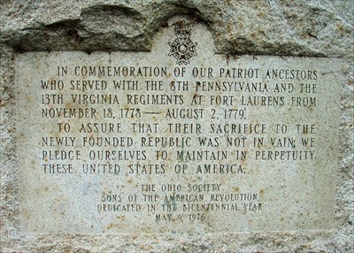
THE OHO SOCIETY
SONS OF THE AMERICAN REVOLUTION
DEDICATED IN THE BICENTENNIAL YEAR
MAY 9, 1976
Further details are offered by Ohio History Central:
Fort Laurens was constructed in the Ohio Country in 1778. During the American Revolution, most Native Americans residing in the Ohio Country allied themselves with the British. While they were neutral in the conflicts, the Christian Delaware Indians were among the few natives who were friendly to the Americans. In the fall of 1778, Lachlan McIntosh served as the commander of an American army sent to the Ohio Country to defeat the Wyandot Indians, strong allies of the English, as well launch an attack against the British garrison located at Detroit, Michigan. During the month of November, McIntosh decided not to carry out his orders due to the winter months that lay ahead. Rather he decided to wait until the warmer spring months before conducting his attacks. He ordered the construction of a fort along the Tuscarawas River (near modern-day Bolivar, Ohio) to help his men survive the harsh winter weather.
Named Fort Laurens, after the president of the Continental Congress, Henry Laurens of South Carolina, the Americans completed the structure by early December 1778. It was to serve three purposes. First, the Americans hoped to utilize Fort Laurens as a base to attack the British garrison located at Detroit. Second, it would hopefully deter natives loyal to the British from conducting raids against American settlers in eastern Ohio and western Pennsylvania. Finally, by offering protection to the neutral Christian Delawares, the Americans might convince them to forsake their neutrality and join the patriots' cause. Unfortunately for McIntosh, his men disliked living in such a hostile environment. Rather than have a mutiny on his hands, McIntosh decided to take the bulk of his men -- just over one thousand of them -- to the safer confines of Fort Pitt in western Pennsylvania. He did leave behind approximately 150 men under Colonel John Gibson's command. Less than two weeks after McIntosh's departure, the men at Fort Laurens rose up against Gibson, but he was able to restore order.
Fort Laurens quickly drew the attention of English soldiers and their native allies in the Ohio Country. In January 1779, Simon Girty, a British agent and interpreter among the Indians, led a small group of Mingo Indians to reconnoiter the fort's defensive features. The men came upon sixteen militiamen from Fort Laurens. They attacked and killed two of the Americans and captured one other. The captive revealed the awful conditions in the fort and the resulting low morale among the Americans. Captain Henry Bird of the English army hoped to take advantage of the situation. With a handful of British soldiers and 180 native allies, consisting of Wyandot, Mingo, Munsee and Delaware Indians, Bird laid siege to Fort Laurens beginning on February 22, 1779.
Gibson learned of the attack before it took place. Half King, a Wyandot chief, had sent messengers to the Moravian communities along the Tuscarawas. He told the Christian Delawares that they either had to assist the Wyandots in their attacks on the Americans or the Wyandots would exterminate the neutral Indians. Delaware chief Killbuck, immediately alerted David Zeisberger, the Moravians' leader, who warned the Americans at Fort Laurens. McIntosh, still at Fort Pitt, quickly sent 120 militiamen to assist the men at Fort Laurens. They arrived too late to be of help. The British had already surrounded the fort, and the American force, believing it would be destroyed if they tried to help the fort's garrison, returned to Fort Pitt.
Throughout late February and early March, conditions in Fort Laurens deteriorated quickly. To avoid starvation, the men became desperate enough to boil their moccasins to make stew. Two men snuck out of the fort to go hunting. They killed a deer. When they returned to their comrades with the carcass, many of the men, ravenous with hunger, ate their portion of the deer meat raw.
Conditions outside of Fort Laurens were only slightly better. The English and the Indians, also facing starvation, lifted the siege of the fort on March 20, 1779. Three days later a relief force, consisting of seven hundred men from Fort Pitt, arrived. As soon as Gibson's men became able to travel, the bulk of the Americans returned to Fort Pitt. Only 106 men, under the command of Major Frederick Vernon, remained behind.
In the meantime, Colonel Daniel Brodhead replaced McIntosh as Fort Pitt's commander. He informed General George Washington of Fort Laurens' inadequacy. It was too far from Detroit to serve as a staging ground to attack the British garrison located there. It also was not close enough to protect the Christian Delawares in Schoenbrunn, Gnadenhutten, and Lichtenau. Washington ordered the fort's abandonment. The last soldiers left Fort Laurens on August 2, 1779.
Fort Laurens was the only fort that the Americans built in the Ohio Country during the Revolution. Once Fort Laurens was abandoned, the Continental Army had no real presence and played no major role in the area for the rest of the war. Militiamen became responsible for the defense of American settlers in eastern Ohio and western Pennsylvania.
Here is a tour of some of the informational signs around the fort site:
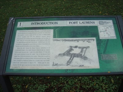
INTRODUCTION
Fort Laurens was constructed in 1778 as part of an ill-fated campaign
led by American Gen. Lachlan McIntosh to neutralize the Indian threat
and establish a western supply post for an attack on British Detroit.
twelve hundred men left Fort McIntosh (present Beaver,
Pennsylvania) and reached the Tuscarawas River on November 18,
1778. Here, in 1764 in the aftermath of the French & Indian War,
Col. Henry Bouquet had built a blockhouse. McIntosh gave the order
to build here, although the neutral Delaware Indians warned him this
location was too far north to protect their villages.
When the fort, named for Henry Laurens, president of the
Continental Congress, was nearly finished, McIntosh and the majority
of the troops returned east. Under Col. John Gibson, 176 men and
five women remained to face the winter. Due to the distance from
supply lines, food and provisions were scarce. The troops resorted to
eating herbs and even boiling ox-hides and moccasins for soup. After
being besieged by British-led Indians for a month, they were finally
relieved by reinforcements in March 1779. Gibson and his men
departed, but the new troops fared no better. The fort was abandoned
in August 1779.
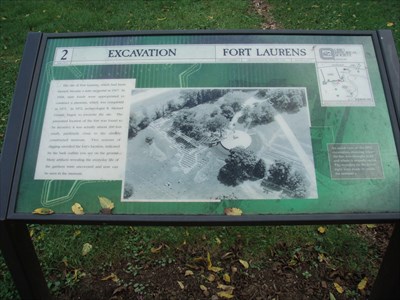
EXCAVATION
The site of Fort Laurens, which had been
farmed, became a state memorial in 1917. In
1968, state funds were appropriated to
construct a museum, which was completed
in 1971. In 1972, archaeologist R. Michael
Gramly began to excavate the site. The
presumed location of the fort was found to
be incorrect; it was actually almost 200 feet
south, perilously close to the already
constructed museum. Two seasons of
digging unveiled the fort’s location, indicated
by the bark outline you see on the ground.
Many artifacts revealing the everyday life of
the garrison were uncovered and now can
be seen in the museum
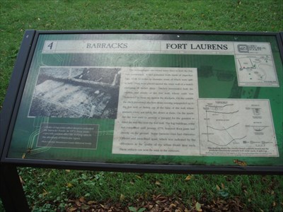
BARRACKS
The archaeologists uncovered many clues to how the fort
was constructed. It had palisaded walls made of unpeeled
logs, 10 to 20 inches in diameter, some of which were split
in half. They were placed against the inner wall of a trench
averaging 36 inches deep. Ditches surrounded both the
outside and inside of the fort wall, where earth was
“borrowed” to heap up against the stockade. On the outside
the ditch prevented attackers from running unimpeded up to
the fort wall or hiding at the base of the wall where
gunners could not safely fire down at them. On the inside,
the dirt was used to provide a ‘parapet’ for gunners to
stand on and fire over the fort wall. The log buildings, some
not completed until January 1779, featured floor joists laid
directly on the ground. Some barracks even had chimneys.
Officers and men lived apart, which was indicated by the
differences in the quality of the refuse found near each.
These artifacts can now be seen in the museum.
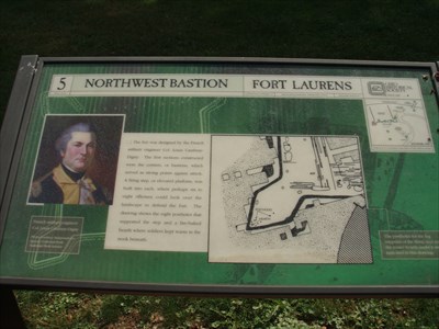
NORTHWEST BASTION
The fort was designed by the French
military engineer Col. Louis Cambray-
Digny. The first sections constructed
were the corners, or bastions, which
served as strong points against attack.
a firing step, or elevated platform, was
built into each, where perhaps six to
eight riflemen could look over the
landscape to defend the fort. The
drawing shows eight postholes that
supported the step and a fire-baked
hearth where soldiers kept warm in the
nook beneath.
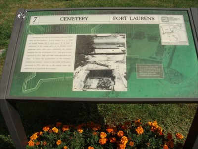
CEMETERY
Twenty-one men died at Fort Laurens and were buried
here, the fort cemetery. Several remains were in single
or double burials, but a mass grave of at least 13
individuals is the resting place of an ill-fated wood-
gathering party who were ambushed by Indians
besieging the fort in February 1779. The graves were
excavated in 1973, 1984, and 1986, when this photo was
taken. It shows the juxtaposition of the cemetery,
hospital and museum. Except for the soldier in the grave
uncovered in 1973, who lies in the nearby tomb, the
other rest in a crypt inside the museum.
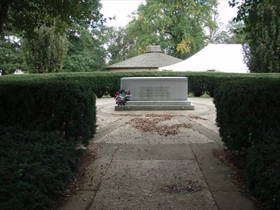
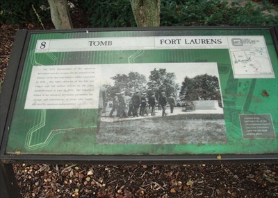
TOMB
The 1976 Bicentennial of the American
Revolution was the occasion for the reburial of the
remains of the first Fort Laurens soldier excavated
in 1973. This fallen defender of the fort was
buried with full military honors by the Ohio
National Guard on June 26, 1976. The unknown
Patriot of the American Revolution personifies the
courage and perseverance of those who fought
and died for American independence.