
Bugang River Footbridge - Guia, Philippines
Posted by:  silverquill
N 11° 44.927 E 122° 04.376
51P E 398983 N 1298941
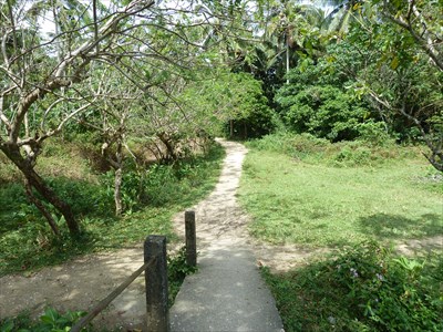
This bridge carries a small path across the Bugang River from Barangay Guia to Barangay Santo Rosario. There are no roads in this interior portion of the river, and this is the only crossing of the river, thus it is a well traveled dirt path.
Waymark Code: WMB5BF
Location: Philippines
Date Posted: 04/07/2011
Views: 3
BUGANG RIVER FOOTBRIDGE
North End Footpath
The Bugang River has won many national and international awards as the cleanest inland waterway in the Philippines. Its mouth at the ocean provides a lagoon and safe harbor for fishing boats, and the upper end features the Malumpati Cold Springs. In between there are a few scattered houses and the small village of Santo Rosario on the north bank. Of the network of paths and trails in this interior portion of the river, only this one makes a crossing on this concrete footbridge completed in 1996 under the sponsorship of the Barangay of Guia.
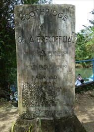
FOOTBRIDGE
GUIA BRGY. OFFICIAL
HON. LEONITA BARRIENTOS
BRGY. CHAIRMAN '94-'96
HON. ESTELITO P. TERRAYO
BRGY. CHAIRMAN '84
KGAWAD
HON. SABAS V. GARCIA
HON. RODEL G. DALES
HON. MANSUETO M. GELLA
HON. CLEMINO C. VALENA
HON. JOSEFA B. TAGNO
HON. PATRICIO G. HINDAP
HON. MELECIO B. EBON
HON. RONALD T. CANDARI
MS. A. DELY C. CANDARI . . . Sec.
NRS. GLORIA T. CANDARI . . . Treas.
CONSTRUCTION STARTED . . . 1984
CONSTRUCTION COMPLETED . . . 1996