
McKellar Hut
Posted by:  StagsRoar
S 44° 52.305 E 168° 08.678
59G E 274451 N 5027329
McKellar Hut is part of the Greenstone Valley walk on Mainland, New Zealand.
Grid reference: Topo50 map sheet CB09, E1216513, N5019822
Waymark Code: WMAZ0
Location: South Island, New Zealand
Date Posted: 04/21/2006
Views: 49
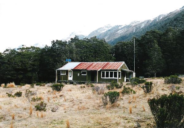
McKellar Hut is sited near the shores of Lake McKellar in the
Greenstone Valley. It has been a number of years since I have personally been back to this hut so I am hoping that the photo does not denote the current condition of this hut as I am quite sure it has had a facelift since this pic was taken. Anyone else who may venture to this hut will hopefully shoot and post a more recent pic of this hut. Acccess to it is either from Lower down the Greenstone Valley via Lake Wakatipu or starting at The Divide on the Milford Highway and crossing over The Divide and passing
Howden Hut and then onto McKellar which is certainly the shorter of the
routes. From the Divide it is a climb and a drop taking about 1 - 1 1/2 hrs to the Howden Hut and from there it is a fairly flat
walk of 2hrs or so to reach the McKellar Hut on a well established track the whole way. From November to May it will pay to book to stay but the rest of the year (wintery months) there is considerably less foot traffic.
Topographical Maps and compass are advised as they are for any back-country travel in
New Zealand especially if any "off track" venturing is to be done. Topographical map references are D41-Eglinton and E41 - Queenstown for those wishing to obtain them. The hut is a serviced hut by the
Department of Conservation and may have some coal for the fireplace on which you can heat water etc but it is still necessary to take Gas Cookers etc. If there is no coal or fuel for the fire then be VERY mindful of taking any deadwood for the fire as the ecosystem in this valley is one that needs to be treated with respect. The hut has bunks and mattress for 12 people only.
The nearby Greenstone River has low trout numbers and is a
Fly Fishing only river and "Catch & Release" is encouraged.
Giardia precautions are a must if taking drinking water from this river.
 Compass & Topographical Map Suggested / Required Compass & Topographical Map Suggested / Required |
| |