
"1790s Footprints" of Keoua's Army ~ Hawai`i; Hawai`i
Posted by:  Jake39
N 19° 21.510 W 155° 21.902
5Q E 251563 N 2142195
Part of Hawaiian National Park.
9.1 miles SW of Park headquarters on Hwy. 11, then foot trail to SE for 1 mile,
Waymark Code: WMAR9B
Location: Hawaii, United States
Date Posted: 02/16/2011
Views: 9
From the National Register Nomination Form:
Statement of Significance
Fossil footprints of Hawaiian men, women, and children, some walking
and some running, with hoof prints of Polynesian hogs, are in a cementlike layer of volcanic ash laid down during the 1790 explosive eruption of Kilauea volcano. The prints are believed to be those left by the warriors, with their families and animals, who served ruling chief Keoua Kuahu'ula. The chief and his company crossed the summit area of the volcano during the eruption enroute to battle with warriors of Kamehameha
A few prints have been preserved under glass in a National Park
Service shelter (Bldg. 55) built in 194O and not a classified structure.
Description;
An area of approximately 428 acres bounded on the northwest
ty the edge of the Keamoku lava flow of aa lava; on the southeast by
the Ka'u Desert Trail; and on the northeast and southwest by irregular
lines; of the Ka'u Desert, which contains an unknown number of fossil footprints
and hoofprints in a surficial ash deposit laid down ca. 1790 during
phreatic explosions of Kilauea volcano originating in Kilauea crater.
1790 Footprints (added 1974 - Site - #74000351)
NATIONAL REGISTER OF HISTORIC PLACES
INVENTORY - "PDF" NOMINATION FORM
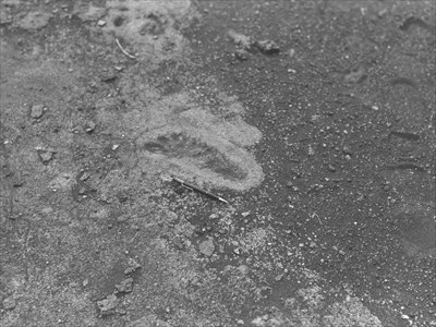 Photo courtesy of the National Park Service
Street address:
Off Highway 11, Hawai`i Belt RoadHI. U.S.A.

County / Borough / Parish: Hawai`i ~ Ka`u Region
Year listed: 1974
Historic (Areas of) Significance: <br><font color="brown"> An event and information potential </font>
Periods of significance: <br><b><font color="red">1750-1799</font></b>
Historic function: <br><font color="blue">Listed as: Other ! ~ Remnents of worrier footprints</font>
Current function: <br><b><font color="green"> Landscape and location information.</font></b>
Privately owned?: no
Primary Web Site: [Web Link]
Secondary Website 1: [Web Link]
Season start / Season finish: Not listed
Hours of operation: Not listed
Secondary Website 2: Not listed
National Historic Landmark Link: Not listed
|
Visit Instructions:
Please give the date and brief account of your visit. Include any additional observations or information that you may have, particularly about the current condition of the site. Additional photos are highly encouraged, but not mandatory.
Recent Visits/Logs:
| There are no logs for this waymark yet. |
|
|
|