An Indian Ambush
Posted by: Groundspeak Premium Member ChapterhouseInc
N 37° 22.727 W 085° 54.174
16S E 597130 N 4137457
How the land became Munfordville.
Waymark Code: WM915
Location: Kentucky, United States
Date Posted: 03/15/2006
Published By:Groundspeak Premium Member ChapterhouseInc
Views: 20

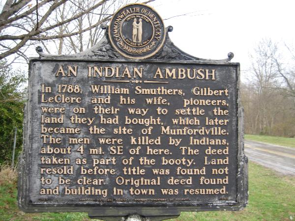
In 1788, William Smuthers, Gilbert LeClerc and his wife, pioneers, were on their way to settle the land they had bought, which later became the site of Munfordville. The men were killed by Indians, about 4 mi. SE of here. The deed taken as part of the booty. Land resold before title was found not to be clear. Original deed found and building in town was resumed.
Marker Name: An Indian Ambush

Marker Location: Roadside

Type of Marker: Other

Marker Number (for official markers): 2454

Group(s) Responsible for placing Marker:
Kentucky Historical Society Kentucky Department of Highways


Visit Instructions:
A picture of the site or anything specific to the text on marker.
Search for...
Geocaching.com Google Map
Google Maps
MapQuest
Bing Maps
Nearest Waymarks
Nearest Kentucky Historical Markers
Nearest Geocaches
Create a scavenger hunt using this waymark as the center point
Recent Visits/Logs:
Date Logged Log User Rating  
Markerman62 visited An Indian Ambush 04/27/2023 Markerman62 visited it
ChapterhouseInc visited An Indian Ambush 03/11/2006 ChapterhouseInc visited it

View all visits/logs