
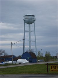
Olcott Beach Water Tower - Olcott Beach, NY
N 43° 20.083 W 078° 43.101
17T E 684963 N 4800513
This water tower is located along Route 18 in Olcott Beach, NY.
Waymark Code: WM8WKW
Location: New York, United States
Date Posted: 05/22/2010
Views: 2
From: Wikipedia
Olcott, New York
Olcott is a hamlet (and census-designated place) located in the Town of Newfane in Niagara County, New York, United States 14126. As of the 2000 census, this community population was 1,156. Most locals refer to it as Olcott Beach. It is part of the Buffalo–Niagara Falls Metropolitan Statistical Area.
Olcott is a lakeside community which is home to the deepest harbor on Lake Ontario west of Rochester, NY. The community is at the junction of East/West Lake Road (NYS Route 18) and Lockport-Olcott Road (NYS Route 78).
Krull Park in the northeast part of the village, is the largest county-operated park in Niagara County. Olcott-Newfane Airport (D80) is located south of the village, but is closed indefinitely except for ultralight aircraft.