
Giant Current Ripples along Washtucna Coulee - Washington
Posted by:  Volcanoguy
N 46° 38.567 W 118° 36.931
11T E 376364 N 5166736
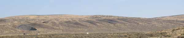
Giant current ripples are visible along Wash. Hwy. 260 in Washtucna Coulee.
Waymark Code: WM8AGN
Location: Washington, United States
Date Posted: 02/28/2010
Views: 14
This location is along Wash. Hwy. 260 about three miles west of Kahlotus in Washtucna Coulee. The location provides a view of and eddy gravel bar with giant current ripples on its surface.
Prior to the great Ice Age floods from glacial Lake Missoula, the Palouse River followed the route of the Washtucna Coulee westward from Washtucna to Connell and then south along the Esquatzel Coulee to the Pasco area where it joined the Columbia River. During the Ice Age floods the huge volumes of water entering the Palouse drainage from the north were so large that east of Washtucna waters spilled southward over a 9-mile wide divide into the Snake River drainage. Eventually these overflow waters carved the present day route for the Palouse River south to the Snake River. But during these Ice Age floods the old Palouse channel was also enlarged and modified to form the Washtucna Coulee of today.
At this location a large eddy bar with giant current ripples developed on the north side of the coulee.
Visit Instructions:
You must actually visit a feature to post a log for it. You must post a picture that you have taken at the feature to have the waymark approved. It has to be in one of the states listed above.