
Beverly Bridge, Washington - Beverly, Washington.
Posted by:  Volcanoguy
N 46° 50.376 W 119° 56.378
11T E 275850 N 5191535
The historic Chicago, Milwaukee, St. Paul & Pacific Railroad bridge across the Columbia River at Beverly, Washington.
Waymark Code: WM876V
Location: Washington, United States
Date Posted: 02/12/2010
Views: 7
The Beverly Bridge was built in 1909 as part of the westward expansion of the Chicago, Milwaukee, St. Paul & Pacific Railroad. The railroad electrified the line about 1920 and added supports to carry the electrical lines on the bridge. In 1980, the railroad went into bankruptcy and abandoned this line. The State of Washington obtained the railroad right of way across the state and has established the Iron Horse State Park along part of the route from Cedar Falls (west end) to the Columbia River (east end). The bridge is closed to all use.
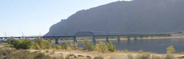
The Beverly Bridge is about 2100 foot long steel bridge. Starting from an earth-filled embankment with concrete abbutment on the west shore there is a steel plate girder span of about 125 feet, then ten 125-foot Warren deck trusses, a 125-foot Parker through truss over the shipping channel, four 125-foot Waren deck trusses, a final 80-foot steel plate girder spanning Wash. Hwy. 243 to a concrete abuttment and earth-filled embankment at east end.
The above information is summarized from http://www.efsec.wa.gov/oplarchive/oplpft/technical_reports/bridgerep.pdf
and http://bridgehunter.com/wa/grant/beverly-railroad/
The coordinates for this waymark are at the end of a short dirt road west of Wash. Hwy. 243, about a third of a mile north of bridge. Coordinates of the bridge would be approximately N 46° 50.018' W 119° 56.541'