
Vantage, Washington
Posted by:  Volcanoguy
N 46° 58.390 W 119° 58.297
11T E 273974 N 5206468
The original location of the community of Vantage, Washington.
Waymark Code: WM8749
Location: Washington, United States
Date Posted: 02/11/2010
Views: 18
The original location of the community of Vantage, Washington was at the mouth of Rocky Coulee on the west shore of the Columbia River at an elevation of about 500 feet. A car ferry was established at this location in 1914 and in 1927 the State build a bridge across the Columbia here. The bridge served until 1962 when it was replaced by the current I-90 bridge. The old bridge was dismantled and moved to the Snake River crossing at Lyons Ferry. Following the opening of I-90 the community was move to a new location at the west end of the I-90 bridge at the mouth of Ryegrass Coulee at an elevation of 700 feet. Construction of the Wanapum Dam, 5 miles downstream, began in 1959 and with the filling of the reservoir in 1963 the original site of the community was covered by about 50 feet of water.
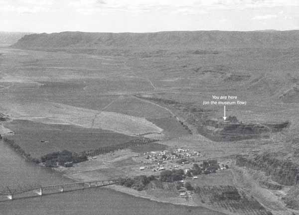
Then
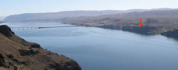
Now
The “Then Photo” was take from a plane looking south along the Columbia River with the original community of Vantage, part of the bridge, and the site of the Ginkgo Petrified Forest Visitor Center showing. The photo comes from a sign at the visitor center and was probably taken sometime in the mid 1950s.
The “Now Photo” was taken from the west bound I-90 viewpoint looking SSW across the Columbia River. Although not exactly the same view it is easy to compare the changes. Coordinates are at the viewpoint.