
"FOUNDING OF OMEMEE"
N 44° 17.935 W 078° 33.611
17T E 694626 N 4907968
This plaque is located at the Coronation Hall at 1 king Street W. in Lindsay.
Waymark Code: WM86RC
Location: Ontario, Canada
Date Posted: 02/08/2010
Views: 9
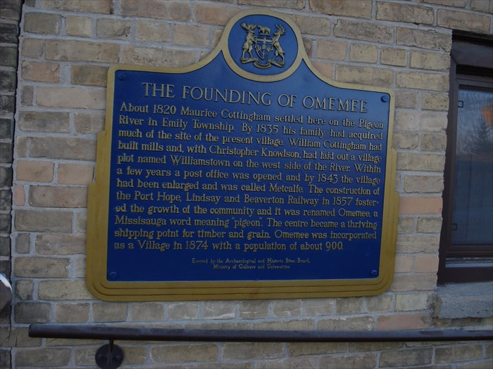
FOUNDING OF OMEMEE
About 1820 Maurice Cottingham settled here on the Pigeon River in Emily Township. By 1835 his family had acquired much of the site of the present village. William Cottingham had built mills and with Christopher Knowlson, had laid out a village plot named Williamstown on the west side of the river. Within a few years a post office was opened and by 1843 the village had been enlarged and was called Metcalfe. The construction of the Port Hope, Lindsay and Beaverton Railway in 1857 fostered the growth of the community and it was renamed Omemee, a Missisauga word meaning "Pigeon". The centre became a thriving shipping point for timber and grain. Omemee was incorporated as a Village in 1874 with a population of about 900.
Address or location of plaque: 1 King Street W.

Physical location of plaque: Village
"Ontario Plaques" Website for this "Plaque": [Web Link]
A web-site for more details.: [Web Link]
Description of any physical remains at site of "Historical Plaque": Omemee still exsist
This 'Plaque' describes: A 'Location'
Condition of sign: Excelent
Is this a bilingual sign?: No !
What is the second/third language?: Only English
|
Visit Instructions:
A "Visited" only remark, will be deleted.
No Waymark owner "Visits" allowed when setting up the Waymark.
Subsequent visits, at another time with photo are acceptable.
NOTE: All photos must include the 'O.H.P.Plaque' at its location to qualify for a "Visited"