
"THE SCUGOG ROUTE" ~ Lindsay
N 44° 20.060 W 078° 43.605
17T E 681230 N 4911520
This plaque is located in the Riverside Cemetery at Linsay Street S. in Lindsay.
Waymark Code: WM86R4
Location: Ontario, Canada
Date Posted: 02/08/2010
Views: 8
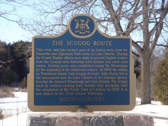
THE SCUGOG ROUTE
This river and lake formed part of an Indian route from the Kawartha and Algonquin Park areas to Lake Ontario. During the French Regime efforts were made to prevent English traders from the Oswego area bartering with Indians who used such routes. Trading posts were established among the Missisauga by the beginning of the nineteenth century. In 1804 the killing on Washburn Island, Lake Scugog, of trader John Sharp, led to the subsequent loss on Lake Ontario of the Schooner Speedy, bearing the accused Missisauga and trial officials. The Scugog, used by settlers seeking land, became fully navigable with the completion of the Purdy Dam at Lindsay in 1830. It is now linked to the Trent-Severn Waterway.
Address or location of plaque: Riverside Cemetery

Physical location of plaque: Town
"Ontario Plaques" Website for this "Plaque": [Web Link]
A web-site for more details.: [Web Link]
Description of any physical remains at site of "Historical Plaque": Still there
This 'Plaque' describes: A 'Location'
Condition of sign: Excellent
Is this a bilingual sign?: No !
What is the second/third language?: English only
|
Visit Instructions:
A "Visited" only remark, will be deleted.
No Waymark owner "Visits" allowed when setting up the Waymark.
Subsequent visits, at another time with photo are acceptable.
NOTE: All photos must include the 'O.H.P.Plaque' at its location to qualify for a "Visited"