
Missouri Compromise - 36° 30' - Enid, Oklahoma
Posted by:  gparkes
N 36° 30.000 W 097° 52.380
14S E 600930 N 4039998
Established in 1820 with the Missouri Compromise law, the effects went straight through to establish the northern border of Texas.
Waymark Code: WM812H
Location: Oklahoma, United States
Date Posted: 01/06/2010
Views: 23
In 1817, Missouri applied to the United States Congress for admission to the Union as a state. Much debate ensued about the ability for Missouri to enter the Union as a slave or free state. Much concern stemmed over political power within the Congress. The United States Senate having two representatives from each state, would see its balance tipped in the direction of 12 slave states or 24 votes within the Senate, verses 11 free states or 22 votes within the Senate.
The debate raged until 1819, when Maine applied to become a state within the Union. Now the debate intensified. The votes would become equal, but how would the remaining territory be allowed for admission to the Union. This is where the line was drawn, 36° 30', in effect by a law signed by President James Monroe, on March 6, 1820. States coming in north of that line would be allowed into the Union only as a free state, States south of that line would be allowed into the Union as a slave state.
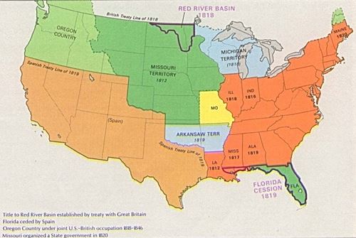
Map of United States in 1820
(Source: http://en.wikipedia.org/wiki/File:USA_Territorial_Growth_1820.jpg Wikipedia Commons accessed on January 6, 2010
This line was drawn across the county effecting the western territories, on how the issue of slavery would be delt with when the territory applied for statehood. In 1836, Arkansas was admited to the Union as a slave state and in 1837 Michigan was allowed in the Union as a free state. Florida entered the Union as a slave state in 1845.
The first border that truly got changed was the northern border of Texas and the land that would become Oklahoma. The Texas Republic as brought into the nation as territory extended to past and into what is now Colorado and Kansas. Rather than apply for admission, as a free state, or apply as a slave state with all territory challenging the Missouri Compromise, the northern border was established at the line of 36 degrees, 30 minutes.
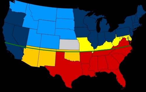
Map of United States with Missouri Compromise line
(Source: http://en.wikipedia.org/wiki/File:Missouri_Compromise_Line.svg Wikipedia Commons accessed on January 6, 2010
As Kansas was admitted into the Union in 1861, it created what was known as "No Man's Land," which is the land making up the panhandle of Oklahoma. This would cause a lawless area made up of crooks. The area of land made from the remainder of Arkansas Territory created Indian Territory. This was the land that was used for the forced relocation of Indians from the east. The routes of the forced relocation of the Indians is commonly referred to as "The Trail of Tears."
Sources and Bibliography:
Encyclopedia Britannica
TeachingAmericanHistory.org
Wikipedia - Images taken for explanation.
Essence and base of information taken from personal knowledge and experience as a student of history. Sources sited as verification to my understanding of the events and specify dates.