The primary purpose of this dam is agricultural. The top of the dam is wide enough to drive over, which I have several times in the pursuit of geocaches. I was sent a letter (Andrew Anderson, Resource Interpretive Specialist @ Double Trouble State Park) stating vehicles are not permitted over the dam so that put an end to that. There is flooding when it rains and the top of the dam will get washed out for periods of time. You can climb down along the cemented boulders and rocks to the bottom of the spillway if you want to get a good look. The dam is numbered fifteen of fifteen of the contributing inventory of structures and sites. The historic district nomination form was written in 1977 and received by the Department of the Interior on October 31st of that year. It was later entered onto the register February 23, 1978. Double Trouble State Park and the preserved historical buildings are all that remain of this once thriving agricultural center. Cranberries and a whole lot of them were the driving force behind this berry mecca. Travel back and time and read on....
"Both of the major cranberry bogs are fed by Cedar Creek which is held back by an earth dam with a pair of wooden gates, (repaired many times). This dam created a large water retention area just northwest of Mill Pond Bog. Cedar Creek passes out of the south end of the bog approximately 700 feet south of the village area. It continues to "snake along" in a southeasterly direction for approximately half a mile where it feeds Gowdy Bog and continues southward. The bogs themselves are criss-crossed with rivulets, by means of which the bogs are emptied and filled several times a year. At present, the bogs are essentially intact but are somewhat overgrown and in need of re-cultivation." --- National Register of Historic Places Inventory -- Nomination Form
Below, there is another interesting narrative I found in the American Guide Series. It explains the source of the name Double Trouble and how it is connected to the dam. The information seems somewhat credible as it was from a source living in the 30's. Back then the story was a hundred years old, today it would have been almost 175 years old and might have been lost to time or changes beyond original recognition.
"Right on this road is Double Trouble, 3.5 m. (50 alt.) more a name than a community, in the pine and cranberry country. Nearly 100 years ago an old preacher and his wife lived near the dam that forms Cedar Creek Lake. A colony of muskrats also resided there and about once a week burrowed through the dam. The parson and his closest neighbor repaired the dam time after time. Once the muskrats dug through twice in the same week, whereupon the preacher cried in despair, "Here's double trouble!". The community is active only when the Double Trouble Cranberry Co. brings in migrant workers during the berry season...." --- New Jersey, a Guide to Its Present and Past, 1939; page 557
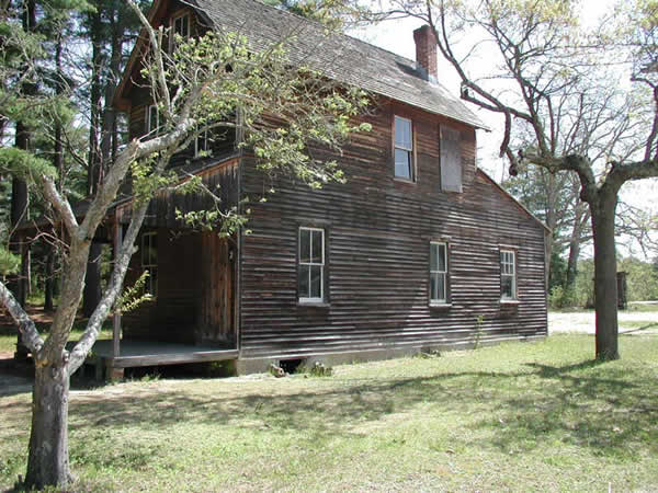
Many years ago, Double Trouble has a vibrant cranberry business as well as a mill company (wood). Today, all is restored. There are tours and interpretive signs as well as tons and tons of hiking trails and a whole mess of geocaches. I had the opportunity to visit this site on many occasion. I also hosted an event here which provided us with a guided tour of the entire complex including the packing plant, the barracks for workers who lived and worked at this site, the saw mill and other important particulars. The original outhouse and single room school house are still there.
Parking is plenty when you first enter. There are many interpretive sign displays which dot the landscape, explaining each artifact, site and remnant of the past. I thought the period graffiti in the packing plant was the most interesting and certainly the most unique artifact of that age. Much of the graffiti or people writing their names or little messages were from the 30's and early 40's and were geared toward Germany and Hitler and of course were very negative.
In our guided tour we learned supplies and materials were in short supply. Building materials were always recycled and used again for another project. When a house or whatever had outlived its purpose, it would be taken apart and used to build something else. For instance, we learned that the barn here was built in the 1950s and made from materials from other buildings in the village which were deconstructed. The people of this company town didn't waste a single scrap of anything! Essentially, this may be the state's first recycled barn.
History:
Originally a cranberry farm and packing plant, the former company town called Double Trouble is a window into past and current industries in the Pinelands. The Double Trouble Company was formed to sell timber, millwork products and cranberries. A succession of sawmills has been on site since the mid-1700s. The village consists of cranberry bogs and fourteen original historic structures dating from the late 19th century through the early 20th century including a general store, a schoolhouse and cottages. The sawmill was restored in 1995, and the cranberry sorting and packing house were completed in 1996.
SOURCE
Please park here: N 39° 53.852 W 074° 13.328
Please enter here: N 39° 53.878 W 074° 13.278
The posted coordinates are for the center of the historic village
*Occasionally, the data base for the NRHP makes a mistake. They list the city for Double Trouble State Park as Beachwood. This is WRONG. Double Trouble Historic District lies in Lacey Twp., and part of it lies in Berkeley Twp. Just for the record.