Indian War Trail - GHM 068-2
Posted by: Groundspeak Premium Member ChapterhouseInc
N 34° 30.430 W 083° 31.426
17S E 268302 N 3821283
The site is a continental divide between the Atlantic Ocean and the Gulf of Mexico, a border
Waymark Code: WM5EV
Location: Georgia, United States
Date Posted: 12/30/2005
Published By:Groundspeak Charter Member snake1411
Views: 43

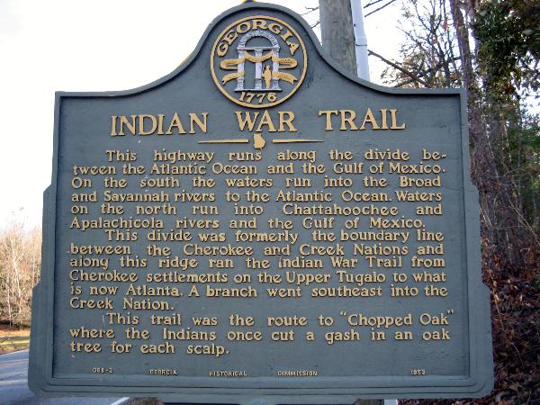
This highway runs along the divide between the Atlantic Ocean and the Gulf of Mexico. On the south the waters run into the Broad and Savannah rivers to the Atlantic Ocean. Waters on the north run into the Chattahoochee and Apalachicola rivers and the Gulf of Mexico.

This divide was formerly the boundary line between the Cherokee and Creek Nations and along this ridge ran the Indian War Trail from Cherokee settlements on the Upper Tugalo to what is now Atlanta. A branch went southeast into the Creek Nation.

This trail was the route to "Chopped Oak" where the Indians once cut a gash in an oak tree for each scalp.

Type of Marker: Highway

Marker #: GHM 068-2

Date: Not listed

Sponsor: Not listed

Visit Instructions:
Take a picture of the marker, yourself at the marker, your gps at the marker, or anything specific to the text on the marker. And don't forget to enjoy your visit.
Search for...
Geocaching.com Google Map
Google Maps
MapQuest
Bing Maps
Nearest Waymarks
Nearest Georgia Historical Markers
Nearest Geocaches
Create a scavenger hunt using this waymark as the center point
Recent Visits/Logs:
Date Logged Log User Rating  
Markerman62 visited Indian War Trail - GHM 068-2 07/24/2012 Markerman62 visited it
Lat34North visited Indian War Trail - GHM 068-2 10/06/2009 Lat34North visited it
Sprinterman visited Indian War Trail - GHM 068-2 01/13/2008 Sprinterman visited it
ChapterhouseInc visited Indian War Trail - GHM 068-2 12/29/2005 ChapterhouseInc visited it

View all visits/logs