This hut sited on the Eastern shore of the Wairaurahiri River near the mouth where it flows into the sea. The Wairaurahiri River has it's beginnings in
Lake Hauroko approx 27 kms up river and the hut is part of the South Coast Track that begins at Blue Cliffs Beach, south of Tuatapere, and continues west around the southern shore line to the Big River area where it becomes a route more than a track and one in which a person can negotiate their way around to Preservation Inlet if they have the time and inclination. The walk to the Wairaurahiri Hut begins at the Rarakau farm car park on Te Waewae Bay and the first leg of this hike takes you to the
Port Craig School House Hut which is approx 7 hrs walk winding around the coast. From there it is another 6 hours of fairly flat easy walking to the Wairaurahiri Hut and on the way you will cross the reknown Percy Burn Viaduct along with another couple of smaller bridges - the Edwin Burn and the Francis Burn. This track has in more recent times been made a loop circuit with a branch off heading north at the Edwin Burn and climbing up the Hump Range. The track from
Port Craig is the remains of an old tramline used for logging in the area at the Port Craig sawmill & township in the 1920's where the schoolhouse hut now is. Several more huts and lodges have been added to this area since the inception of the
Hump Range Track and has increased in popularity somewhat to a point where you will most often be on the track or in huts with other
Tramping
/hiking parties. The Wairaurahiri hut can also be accessed an easier way - via jet boat, of which there are several operators for these on this river. This would entail starting at the Lake Hauroko Boat jetty and heading down the lake and then down the river. A few online sites exit to be able to query this option. This hut used to be mainly used by
Hunting parties and I would imagine a fair share still do but I would tend to think that it is now mainly trampers. There is a lodge across the swingbridge over the river outside the hut which has been built only since I was last at this hut so I am not sure of it's usage or proximity to the Wairaurahiri hut, but I understand it is only a stones throw across the river to it and I believe it is used by guided walkers only. The Wairaurahiri Hut is a 14 Bunk hut with mattresses and has a stove for heating but you will need to bring gas cookers. Don't go on a deforestation frenzy looking for wood to burn - just use what you need and make it dead wood only. The mouth of the river is better accessed by crossing the swing bridge and following the river down on the true right. As I remember it is approx 15 min walk to the mouth on a semi-formed track. A good walk in this is and a good hut at the time of my stay so keep it clean and leave it in good condition should you stay.
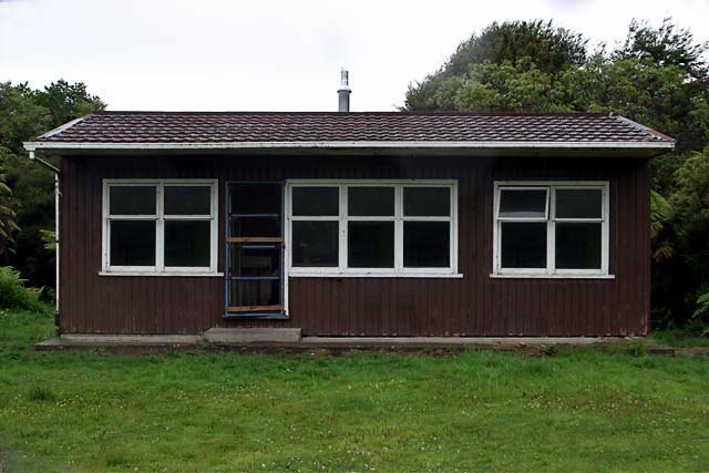
Close Up of the hut above.
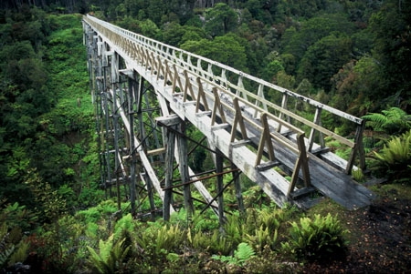
Crossing the Percy Burn Viaduct if walking in from Port Craig.
 Hunters often in the area Hunters often in the area |
 Compass & Topographical Map Suggested / Required Compass & Topographical Map Suggested / Required |
 Approx 16 Hrs Hiking required Approx 16 Hrs Hiking required |
 Wear Insect Repellant! Wear Insect Repellant! |
 No Dogs Allowed No Dogs Allowed |
 Bring A Camera Bring A Camera |