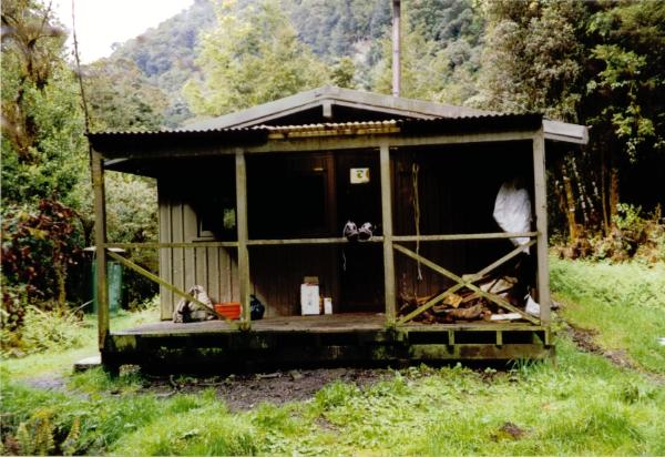
Glaisnock Valley Hut
Posted by:  StagsRoar
S 44° 59.909 E 167° 41.822
58G E 712573 N 5013679
Glaisnock Hut is sited in the Glaisnock Wilderness Area of Fiordland, New Zealand and is surrounded by pristine Forest & Mountains.
Waymark Code: WM55Q
Location: South Island, New Zealand
Date Posted: 12/22/2005
Views: 53

This hut is most frequently visited by
Hunters &
Fishermen and is accessible by boat only, up & across Lake TeAnau at the head of the North Arm. Boating up this arm can be harrowing as weather funnels out of the mountains and down the valley to the lake so pick your day! It is a sizeable journey and boats can be launched at TeAnau Township itself which would make it considerably longer or by launching from TeAnau Downs which will nearly halve the trip but still be significant in a small boat. The trip along the North Arm involves passing the Luger Burn and going through the Narrows to the head of the arm.
The hut itself has bunks & matresses for 12 people and has a pot-belly stove for heating. Take gas cookers! Be it that you need a boat to get there I would advocate taking your own sack of coal for the fire and not be hacking away at wood from the surrounding
Native Forest.
There are no tracks up this valley but rather it can be negotiated by creating your own route through the dense forest that it is.
Topographical Map and compass is a must and
GPS coverage could be scant under the forest canopy.
The Glaisnock River is photogenic and is a few minutes bush bash straight out from the from the front door of the hut and can't be waded. Be cautious of this rivers ability to rise and fall given rain and storms up the valley and in the mountains that you may no nothing about.
Leave this hut clean and tidy should you go there and don't forget to take your camera should you visit it either. The scenery here typifies
Fiordland /
New Zealand.
 Hunting in area - use caution Hunting in area - use caution  (Boat required) (Boat required)  Accessible in Winter Accessible in Winter
 Compass & Topographical Map Suggested / Required Compass & Topographical Map Suggested / Required  Weather Permitting Weather Permitting  Wear bug repellant! Wear bug repellant! |
| |