
Stanley's Sector - GHM 060-81 - Fulton Co., GA
Posted by:  Lat34North
N 33° 46.184 W 084° 21.400
16S E 744796 N 3739765
Stanley's Sector state historic marker located at Ralph McGill Blvd just west of Linwood St, Atlanta, GA.
Waymark Code: WM4D0J
Location: Georgia, United States
Date Posted: 08/07/2008
Views: 14
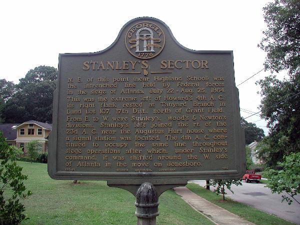 Stanley's Sector
N.E. of this point (near Highland School) was the intrenched line held by Federal forces in the siege of Atlanta, July 22-Aug. 25, 1864. This was the extreme left of Howard's 4th A.C.; its right flank rested at Tanyard Branch in Land Lot 107, 17th Dist., north of Grant Field. From E. to W. were Stanley's, Wood's & Newton's divisions. Stanley's left joined the rt. of the 23d A.C. near the Augustus Hurt house where a signal station was located. The 4th A.C. continued to occupy the same line throughout siege operations after which, under Stanley's command, it was shifted around the west side of Atlanta in the move on Jonesboro.
GHM 060-81 GEORGIA HISTORICAL COMMISSION 1956