
Johnston's River Line - GHM 033-072 - Cobb Co. GA.
Posted by:  Lat34North
N 33° 48.003 W 084° 30.854
16S E 730119 N 3742764
Johnston's River Line state historic marker located on US 78 at Oakdale Rd.
Waymark Code: WM45B8
Location: Georgia, United States
Date Posted: 07/09/2008
Views: 9
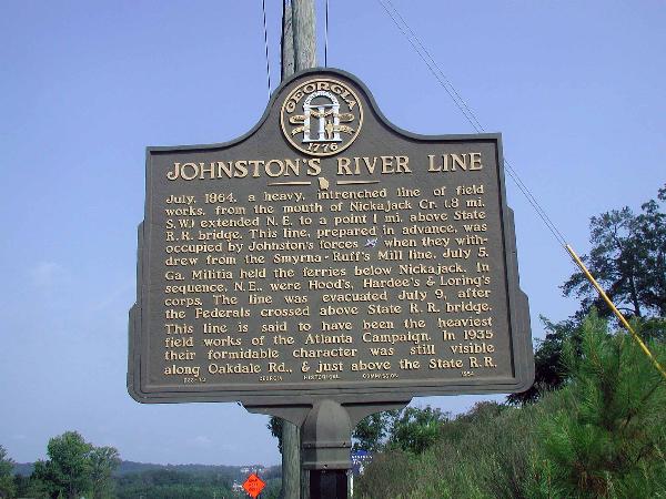 Johnston's River Line
July, 1864, a heavy, intrenched line of field works, from the mouth of Nickajack Cr. (.8 mi. S. W.) extended N. E. to a point 1 mi. above State R. R. bridge. This line, prepared in advance, was occupied by Johnston's forces [CS] when they withdrew from the Smyrna - Ruff's Mill line, July 5. Ga. Militia held the ferries below Nickajack. In sequence, N. E., were Hood's, Hardee's & Loring's corps. The line was evacuated July 9, after the Federals cross above State R. R. bridge. This line is said to have been the heaviest field works of the Atlanta Campaign. In 1935 their formidable character was still visible along Oakdale Rd., & just above the State R. R.
033-72 GEORGIA HISTORICAL COMMISSION 1954