|
 Ebbetts Pass Scenic Byway - Ebbetts Pass, Elevation 8,730 ft
N 38° 32.642 W 119° 48.738
11S E 254900 N 4269929
The highest point of California's State Route No. 4
Waymark Code: WM3XFW
Location: California, United States
Date Posted: 05/31/2008
Views: 44
 Click on any picture for larger images and click the blue links for other nearby waymarks.
|
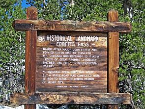
416 ft higher than Monitor Pass, this is the highest point of this Scenic Byway. The pass follows an old trading route used by the local Miwok and Washoe People. The first European American to cross this pass was most likely Jedediah Smith in 1827. However, Ebbetts Pass is named after John Ebbetts, who came here in 1851, 24 years after Jedediah Smith, in search for a suitable route for the Transcontinental Railway. |
|
|
Caution: This pass is subject to seasonal closures.
The route is very scenic, but it is also very narrow and windy and not suited for RVs or other big vehicles. On our way up to the pass we took a couple of pictures through the front window to proof our point. |
|
|
Program: America's Byways

Website: [Web Link]
Official Name: Ebbetts Pass Scenic Byway
|
Visit Instructions:
Please give a brief description of your visit. Maybe why you were there, what you found interesting, or something along those lines. Photos are also encouraged. Although the only requirement to log a visit to a waymark in this category is to physically visit the location, the photos and extra information you can provide about the area is very helpful to future visitors.
|