|
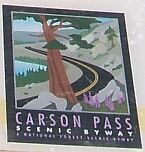
 Carson Pass Highway - Carson Pass
N 38° 41.633 W 119° 59.250
11S E 240170 N 4287043
The highest point of California's State Route 88
Waymark Code: WM3WM3
Location: California, United States
Date Posted: 05/26/2008
Views: 91
 Click on any picture for larger images and click the blue links for other nearby waymarks.
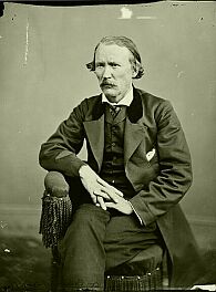 Kit Carson, 1809-1868
|
|
8,574 feet above sea level, Carson Pass is one of six passes across the crest of the highest mountains in the Continental US. It is one of only three passes that are open whole year long.
Today, crossing the Sierra Nevada on State Route 88 is not as popular as the two big highways, No. 80 over Donner Pass and No. 50 over Echo Summit, but only 150 years ago, this was the main route into California.
The pass is named after frontiersman, trapper and scout Kit Carson who was the first European American to cross the mountains on what was then an Indian trading route. An extensive biography of Kit Carson can be found at Wikipedia.
|
 |
|
A Brief History of Carson Pass
The Washo People who traditionally lived in this area used a trading route across this pass four hundreds of years.
|
|
In 1844, John C. Fremont and Kit Carson followed the old Indian route. The five-month journey, made with 25 men, was a success, and Fremont's report was published by the U.S. Congress. It touched off a wave of wagon caravans filled with hopeful emigrants heading west. As part of the California Trail, the route over Carson Pass became the most heavily used Sierra crossing for farmers and gold-seekers to reach the gold fields and farm homesteads in California. It has been estimated that between 1844 and 1860 a quarter million people made the journey along this road.
A migration in the opposite direction started in 1862 when silver was discovered in Comstock Lodge, Nevada, leading to the construction of a formal road, called the
Amador-Carson Valley Wagon Road.
|
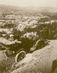
With the advent of the automobile in 1911, the old wagon road was replaced by the Alpine State Highway. The narrow, windy road accommodated animals, wagons, and the first slow moving cars.
After a road widening project in the 1930s, the road was improved again in 1958, following the construction of Lower Bear Reservoir.
Nowadays, thanks to the Interstate Highway System, this pass is used less frequently, but it is still one of the most scenic ways to cross the Sierra Nevada. |
|
Program: USDA Forest Service Byways

Website: [Web Link]
Official Name: Carson Pass Highway (Route 88)
|
Visit Instructions:
Please give a brief description of your visit. Maybe why you were there, what you found interesting, or something along those lines. Photos are also encouraged. Although the only requirement to log a visit to a waymark in this category is to physically visit the location, the photos and extra information you can provide about the area is very helpful to future visitors.
|