|
 Tenmile Creek Cascades
N 36° 49.969 W 118° 52.825
11S E 332313 N 4077976
A short, cascading river in Kings Canyon
Waymark Code: WM3TKT
Location: California, United States
Date Posted: 05/16/2008
Views: 24
 Click on any picture for larger images and click the blue links for other nearby waymarks.
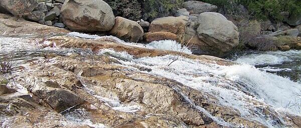
Tenmile Creek in Giant Sequoia National Monument is a very short creek. It is only - yes, you guessed it - ten miles long. But on its short way from Hume Lake to the Kings River it drops an amazing 3,000 feet in elevation, turning the entire river in one never ending rapid.
If you want to rough it you can probably climb along the creek for its entire length, but we found two places with relatively easy access:
Trailhead 1 at N 36° 48.989' W 118° 53.313'
|
Trailhead 2 at N 36° 49.821' W 118° 52.623'
|
|
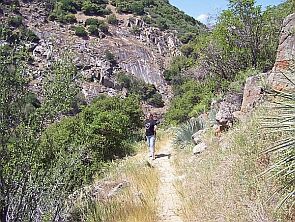
This is Yucca Point Trail, leading all the way down to the Kings River. About half way, at N 36° 50.185' W 118° 52.816' (picture right) is a junction to a short, steep trail leading directly to Tenmile Creek, just below the largest waterfall along the creek (main picture and main coordinates).
We hiked the trail all the way to its end, just to find out that the best place to see the waterfall is actually directly at the junction.
|
|
Check out Waterfalls of California for a good description of the main fall.
Type: Cascade

Watercourse: Tenmile Creek
Waterfall Height: 30
Seasons of Best Flow: From: 01/01/2008 To: 12/31/2008
Viewpoint: Middle
Path Up and Down: Partial
Walk Behind: Partially
Parking Coordinates: Not Listed
Seasonality: Not listed
|
Recent Visits/Logs:
| There are no logs for this waymark yet. |
|
|
|
|