24U3265 - MMMCCLXV - IBC Marker 37
Posted by:  Hard Oiler
N 42° 43.067 W 082° 28.641
17T E 379032 N 4730533
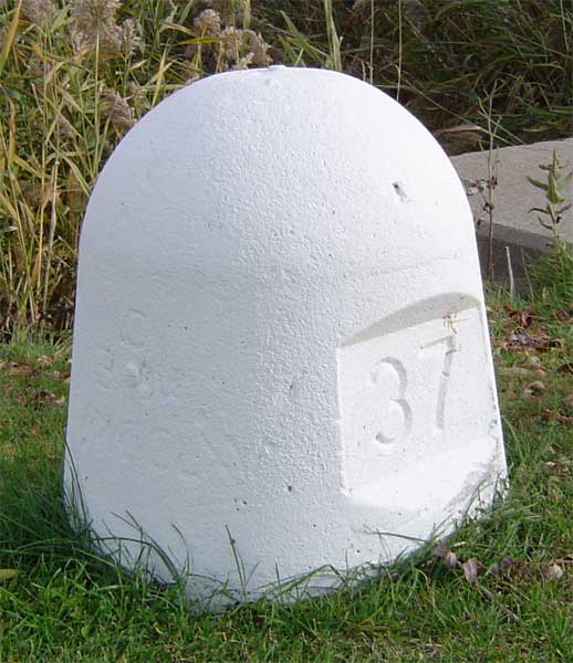
IBC Marker 37 is one of the land based International Boundary Commission markers used to define the US/Canada border along the St Clair River between Michigan and Ontario
Waymark Code: WM3R1
Location: Ontario, Canada
Date Posted: 11/14/2005
Views: 40
The International Boundary Commission is responsible for defining the 8,891 km border between the US and Canada. The treaty of 1908 made provision to mark the 3,830 km of water boundaries and resulted in a series of virtual “turning points” connected by straight lines referenced to land-based monuments. A number of these land-based monuments can still be found although the coordinates listed are scaled, listed only to the nearest second, and not too reliable.
In this area, the boundary follows the St Clair River between Ontario and Michigan and IBC monuments are located on both sides of the river
IBC Marker 37 – MMMCCLXV, placed in 1924, is located on the St Clair parkway in Sombra. Listed in the CSRS database as being at N N 42°43’05” W82°28’41” (42° 43.08 W 82°28.68) and at an elevation of 177 metres (my GPSr gave 179)with the description
INTERNATIONAL BOUNDARY COMMISSION CONCRETE REFERENCE MONUMENT NO. 37, ON EAST SIDE OF OLD HIGHWAY NO. 40, AT INTERSECTION WITH LAMBTON COUNTY ROAD NO. 2, 0.8 KM NORTH OF SOMBRA FERRY LANDING, AT SOUTH BOUNDARY OF ROMAN CATHOLIC CHURCH PROPERTY, BOLT FACING NORTH