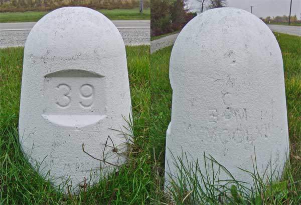
24U3262 - MMMCCLXII - IBC Marker 39
Posted by:  Hard Oiler
N 42° 45.722 W 082° 27.764
17T E 380314 N 4735426
IBC Marker 39 is one of the land based International Boundary Commission markers once used to define the US/Canada border along the St Clair River between Michigan and Ontario
Waymark Code: WM3QY
Location: Ontario, Canada
Date Posted: 11/14/2005
Views: 32
The International Boundary Commission is responsible for defining the 8,891 km border between the US and Canada. The treaty of 1908 made provision to mark the 3,830 km of water boundaries and resulted in a series of virtual “turning points” connected by straight lines referenced to land-based monuments. A number of these land-based monuments can still be found although the coordinates listed are scaled, listed only to the nearest second, and not too reliable.
In this area, the boundary follows the St Clair River between Ontario and Michigan and IBC monuments are located on both sides of the river
IBC Marker 39 – MMMCCLXII, placed in 1924, is located on the west side of the St Clair Parkway and is one of the best preserved of the ones in the area with the roman numeral markings being still visible below the south facing bolt . Surprisingly it would appear that the markers are still maintained as the ones in this area have recently been repainted white. Listed in the CSRS database as being at N 42°45’40” W 82° 27’.47” (N 42° 45.67 W 82° 27.78) and at an elevation of 1809 metres (my GPSr gave 185) with the description:
INTERNATIONAL BOUNDARY COMMISSION CONCRETE REFERENCE MONUMENT NO. 39, 6.4 KM NORTH OF SOMBRA FERRY LANDING, 9.1 M WEST OF CENTRE LINE OF OLD HIGHWAY NO. 40, ABOUT 457 M SOUTH OF SOMBRA-MOORE TOWNSHIP LINE, BOLT FACING SOUTH.