
Lewis & Clark Tour - St. Charles, Missouri
Posted by:  BruceS
N 38° 46.383 W 090° 28.941
15S E 718717 N 4294602
Short walking tour in historic St. Charles, Missouri, to bring you to a few Lewis and Clark sites.
Waymark Code: WM3QJ5
Location: Missouri, United States
Date Posted: 05/05/2008
Views: 81
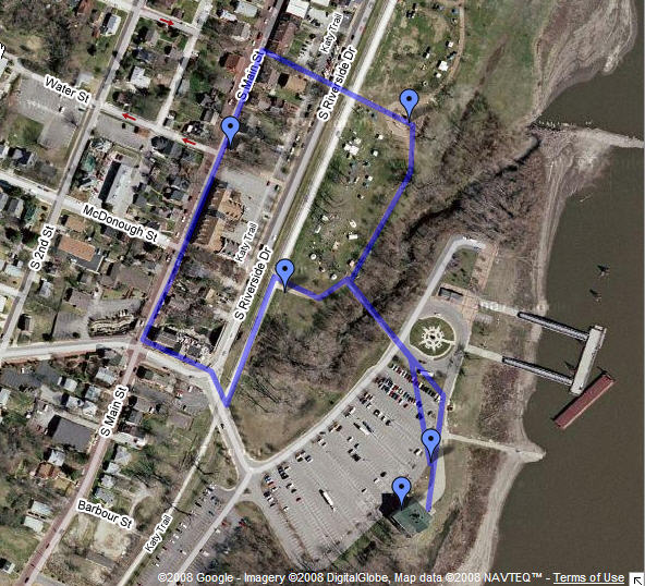
This tour will be a walking tour of about 3/4 of a mile. It will visit
different Lewis and Clark sites among others in the river front and historic St.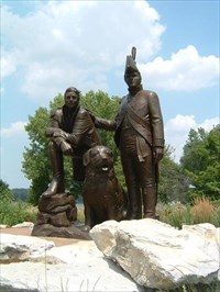 Charles.
Start your tour in the large parking lot in front of the Lewis & Clark
Boathouse and Nature Center (Coordinates above). Visit the Boathouse and
Nature Center, downstairs are replicas of a keelboat and pirogues used by the
Lewis and Clark Expedition and the nature center upstairs has displays of what
wildlife was like during the Lewis and Clark era.
Once exiting the Boathouse and Nature Center go north to N 38° 46.399 W 090°
28.926 where you will find a 12' Lewis and Clark commemorative disk, along the
way stop to read this historical markers and watch the river flow by. Once
finding the survey marker head northwest toward N 38° 46.456 W 090°
28.927, a beautiful Veterans Memorial . From the Memorial you will see a
walking bridge across a creek. Cross the bridge and head to the Lewis &
Clark Monument in Frontier Park (N 38° 46.557 W 090° 28.940). This
monument has a bigger than life size statue of Lewis and Clark along with their
dog Seaman. There are also various plaques about their journey.
From the monument you can also get a good view of the river.
From the Monument head west though the opening in the fence and cross the
street at the cross walk and walk 1 block west. At this time you will be
on St. Charles Historic Main Street, a Historic District on the National
Register. Once arriving at Main Street the tour goes south however if you
want to experience more the historic district walk a few blocks north and then
come back south.
As you walk south you will see many building built in the 1800's and the
streets and sidewalks will be brick. There will be many shops along the way.
The next stop is a marker stone placed by the D.A.R. commemorating the
Lewis & Clark Expedition (N 38° 46.542 W 090° 29.045). Continue south on
Main Street until you get to the old mill at the corner of Main St and Boonslick
Road (Trailhead Brewery). The Brewery is a good place to stop for a drink
or a bite to eat if you desire. Turn east on Booneslick and cross
Riverside Drive. Once crossing Riverside turn north for a short distance
on the Katy Trail (The Katy Trail extends in excess of 200 miles to the west as
a bicycling and walking trail). The next stop is the Lewis & Clark
Campsite (N 38° 46.479 W 090° 29.013). The is the location the Expedition stayed
for five days May 16-20, 1804 and again September 21, 1806 on their return.
From here follow the trail along the wood line back to the bridge and then back
to the parking lot.
This tour will bring you past 20 - 30 waymarks and deviating from it just
slightly will result in that many or more.