
Battle Of Pickett's Mill (2) – GHM 110-27 – Paulding Co., GA.
Posted by:  Lat34North
N 33° 59.114 W 084° 44.724
16S E 708263 N 3762809
Battle of Pickett's Mill state historic marker located on the west side of the Hiram Acworth Highway (92) at the entrance to the Battle Of Pickett's Mill Group Shelter. - do not confuse this with the other Battle Of Pickett's Mill marker at the park.
Waymark Code: WM3HZ3
Location: Georgia, United States
Date Posted: 04/09/2008
Views: 14
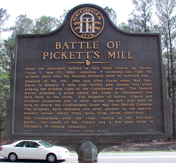 BATTLE OF PICKETT'S MILL
After the successful defense at New Hope Church by Hood's Corps [Confed.], May 25, 1864, Johnston [Confed.] extended his right NE to keep pace with the Federal leftward shift to outflank him. Elements of the 4th, 14th and 23rd Corps under Maj. Gen. Oliver O. Howard [Union] with over 18,000 men passed this point seeking the extreme right of the Confederate army. The Federal forces attacked a point where the Army of Tennessee's line bent back to the south. The brigades of Hazen, Gibson and Scribner blundered into a deep ravine one-half mile east of here to attack the Confederates under Maj. Gen. Patrick Cleburne. The brigades were defeated one after another in the heavily-wooded ravine where fired upon from three directions.
The Confederates were the clear victors of the five-hour battle. The result of the victory was a few days delay in Sherman's [Union] Atlanta Campaign.
110-27 GEORGIA HISTORIC MARKER 1983
There are two historic markers titled “BATTLE OF PICKETT'S MILL”. Both markers have the same number (110-27) and the same text.