
Cherokee - Seneca Boundary OK
N 36° 37.481 W 094° 48.916
15S E 337686 N 4054772
The Cherokee and Seneca Boundary Marker Oklahoma
Waymark Code: WM3A2N
Location: Oklahoma, United States
Date Posted: 03/03/2008
Views: 49
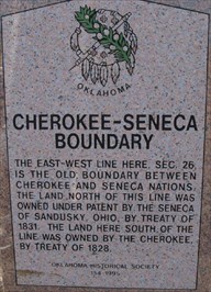
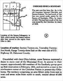
CHEROKEE - SENECA BOUNDARY
The above information is from the book, Mark of Heritage, by Muriel H. Wright, courtesy of Oklahoma Historical Society.
WIKI MAP
Photos by: GEO*Trailblazer 1
Type of Nation Within: Native American Indian Reservation (USA)

Tribe or Band: Cherokee - Seneca
Address of Main Entrance to area:
Hwy 59
Grove, OK USA
Land Area - Specify Acres or Miles: Almost all of Oklahoma
Population: 64,000 +
Date when area was established or set aside: 01/01/1828
Open or Closed to Public: Open To Public
Website for further information: [Web Link]
Coordinates of site within area to visit: Not Listed
|
Visit Instructions:
Only one waymark per area (reservation) will be accepted, although you may log visits anywhere within the reservation because they oftentimes cover a large area. To log a visit to the waymark, please provide a photo of signage recognizing the area and a photo from within the area.