 Faro de Punta Teno (Tenerife/Canary Islands)
Posted by:  Q10
Q10
N 28° 20.530 W 016° 55.363
28R E 311534 N 3136608
From the Punta de Teno, the most westerly point of the island, which is marked by an old lighthouse, there are spectacular panoramic views of the Gigantes Cliffs, which drop straight down to the sea from a height of almost 600 metres.
Waymark Code: WM2YDK
Location: Spain
Date Posted: 01/10/2008
Views: 185
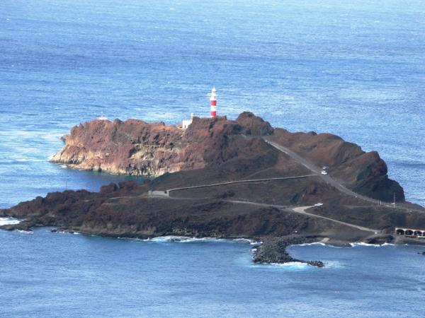
Faro de Punta Teno is situated on a startling spit of vulcanic rock
leaning out into the Atlantic Ocean. Really a wild place to put a lighthouse.
And worth a visit indeed. But you can only get here in a car or by a bike.
Punta de Teno devide the island Tenerife in north and south. The Atlantic
Ocean is wild on the north side and calm on the other. Also the wind from the
mountains meets here. These two facts is the reason that this place is special.
To get to the Punta de Teno you have to follow the coast road that leaves from the centre of the town of Buenavista del
Norte. The distance is 10km. Importent: As signs warn you, the road to Punta de Teno is dangerous during
heavy rain and strong winds, due to rockfalls! The road to Punda de Teno wind
its way round and under rough intented cliffs, high above the sea. At the end
the road descends to the lighthouse on the dark volcanic promontory of Punta de Teno.
The
area on Punta de Teno is one of the richest botanical areas in the Canaries.
Swimming off the rocks in the crystal clear water here is a must!
Read facts about the lighthouse (in spanish): Faro
de Punta Teno.
Read more about Teno Rural Park.