
Stevenson's Division - GHM 060-77 – Fulton Co., GA
Posted by:  Lat34North
N 33° 47.506 W 084° 22.033
16S E 743756 N 3742184
Stevenson's Division State Historical Marker located on the south side of Dutch Valley Rd at Monroe Dr, Atlanta.
Waymark Code: WM2XTZ
Location: Georgia, United States
Date Posted: 01/06/2008
Views: 21
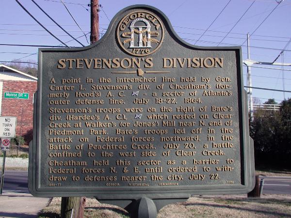 STEVENSON'S DIVISION
A point in the intrenched line held by General Carter L. Stevenson’s division of the Cheatham’s (formerly Hood’s) A.C. [Confederate] ~ a sector of Atlanta’s outer defense line. July 18-22, 1864.
Stevenson’s troops were on the right of Bate’s division (Hardee’s A.C.), [Confederate] which rested on Clear Creek at Walker’s (or Jones’) Mill near North end of Piedmont Park. Bate’s troops led off in the attack on Federal forces northward, in the Battle of Peachtree Creek, July 20, a battle confined to the west side of Clear Creek.
Cheatham held this sector as a barrier to Federal forces North and East until ordered to withdraw to defenses nearer the city, July 22.
GHM 060-77 - Georgia Historical Commission - 1956