
Site: Cobb's Mill - GHM 044-58 - DeKalb Co., GA
Posted by:  Lat34North
N 33° 42.094 W 084° 19.939
16S E 747247 N 3732262
Site: Cobb's Mill - State Historical Marker located at 1510 Key Rd. at Intrenchment Creek Water Plant just east of Atlanta city limits. See note in long description.
Waymark Code: WM2T58
Location: Georgia, United States
Date Posted: 12/17/2007
Views: 28
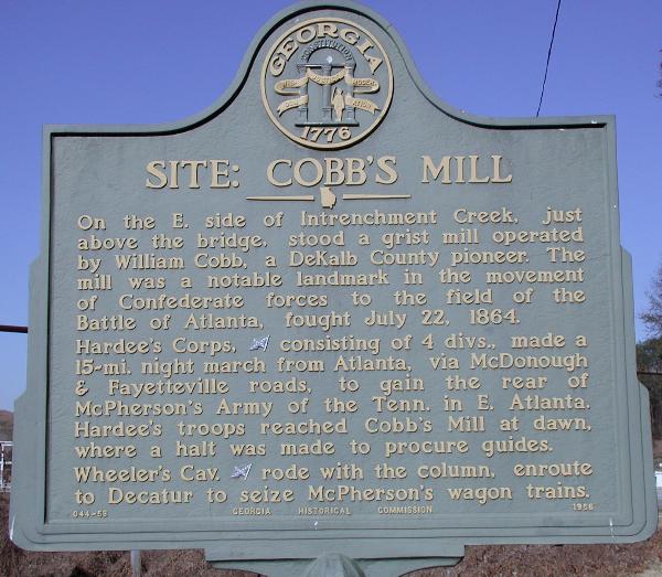 SITE: COBB'S MILL
On the e. side of Intrenchment Creek, just above the bridge, stood a grist mill operated by William Cobb, a DeKalb County pioneer. The mill was a notable landmark in the movement of Confederate forces to the field of the Battle of Atlanta, fought July 22, 1864.
Hardee's Corps, [CSA] consisting of 4 divs., made a 15-mi. night march from Atlanta, via McDonough & Fayetteville roads, to gain the rear of McPherson's Army of the Tenn. in E. Atlanta. Hardee's troops reached Cobb's Mill at dawn, where a halt was made to procure guides.
Wheeler's Cav. [CSA] rode with the column, enroute to Decatur to seize McPherson's wagon trains.
GHM 044-58 - Georgia Historical Commission - 1956
NOTE: NOTE: I parked on the entrance road and walked to the markers that are at least 100 yards from the fence/gate. I did not see any signs saying anything about no Photographs, but the guard at the gate told me I could not take any photographs, even of the Historical marker and that I was on City Property. Of course since I was so far from the guard house I had already taken the pictures and was actually ready to walk back to my car when she made such a big fuss over it all. I asked the guard to check and see if we were really not allowed to take pictures of the markers but left before she found out (it was about 35 degrees).