
Old Williams Mill Rd – GHM 060-78 – Fulton Co., GA
Posted by:  Lat34North
N 33° 46.487 W 084° 20.933
16S E 745502 N 3740343
Old Williams Mill Rd. State Historical Marker located on the east side of Briarcliff Rd. between St. Charles Pl. and St. Augustine Pl. in Atlanta, GA.
Waymark Code: WM2KEF
Location: Georgia, United States
Date Posted: 11/15/2007
Views: 37
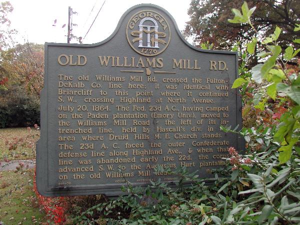 OLD WILLIAMS MILL RD.
The old Williams Mill Rd. crossed the Fulton-DeKalb Co. line here; it was identical with Briarcliff to this point where it continued S.W., crossing Highland at North Avenue.
July 20, 1864. The Fed. 23d A.C., having camped on the Paden plantation (Emory Univ.), moved to the Williams Mill Road -- the left of its intrenched line, held by Hascall's div. in the area where Druid Hills M.E. Church stands.
The 23d A.C. faced the outer Confederate defense line along Highland Ave., & when that line was abandoned early the 22d, the corps advanced S.W. to the Augustus Hurt plantation on the old Williams Mill Road.
GHM 060-78 - Georgia Historical Commission - 1956
This marker is on the back side of a hedge and is difficult to see from the street.