Historic Elbe Bridge in Torgau
Posted by: Groundspeak Regular Member Bernd das Brot Team
N 51° 33.581 E 013° 00.565
33U E 362015 N 5713944
Marking the "Flood of the Century" of 2002
Waymark Code: WM2FJB
Location: Sachsen, Germany
Date Posted: 10/25/2007
Published By:Groundspeak Regular Member GEO*Trailblazer 1
Views: 94

This gauge is located at the remains of the Historic Elbe Bridge in Torgau, Germany. Water levels of the Elbe River vary a lot depending on rain and snowfall in the mountains.


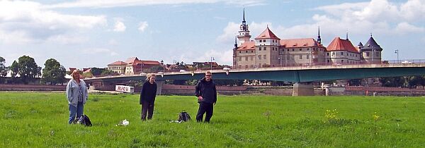
The team walking on the flood plains - dry in 2007, but often completely flooded.

When we visited the place in Summer 2007, it was completely dry and the river was about 150 feet wide and peaceful. But after heavy rain in the mountains, the place looks dramatically different and all the green meadows we walked on are then completely under water (like in this historical picture of the 2002 flood shown below).

High Water in 2002 Low Water in 2007


The highest water level ever was measured during the
Flood of the Century on August 18, 2002 at 9.45 meters (31 feet).

RIVER GAUGE INFORMATION:
There is a marker marking the highest water level ever measured at this river


ANY ADDITIONAL WAYPOINT: Not Listed

WEB LINK FOR RIVER GAUGE: Not listed

Visit Instructions:

Log Waymark with coordinates and your images of the River Gauge.
"At least one picture must have the gauge plus you in the view".
Search for...
Geocaching.com Google Map
Google Maps
MapQuest
Bing Maps
Nearest Waymarks
Nearest River Gauges
Nearest Geocaches
Create a scavenger hunt using this waymark as the center point
Recent Visits/Logs:
Date Logged Log User Rating  
Blogi visited Historic Elbe Bridge in Torgau 07/11/2017 Blogi visited it
D1k74 visited Historic Elbe Bridge in Torgau 08/15/2009 D1k74 visited it
spartak visited Historic Elbe Bridge in Torgau 08/27/2007 spartak visited it
MNZL visited Historic Elbe Bridge in Torgau 07/16/2005 MNZL visited it

View all visits/logs