
Cleburne Outflanked Left Wing, 17th A.C. - GHM 044-64 – DeKalb Co., GA.
Posted by:  Lat34North
N 33° 44.437 W 084° 20.659
16S E 746023 N 3736564
Cleburne Outflanked Left Wing, 17th A.C State Historical Marker
Located on Haas Avenue north of Glenwood Ave, East Atlanta.
Waymark Code: WM2DHN
Location: Georgia, United States
Date Posted: 10/16/2007
Views: 26
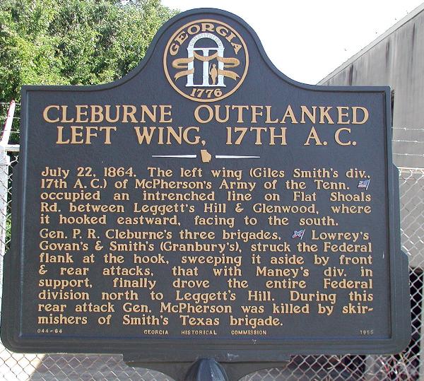 CLEBURNE OUTFLANKED LEFT WING, 17TH A.C
July 22, 1864. The left wing (Giles Smith’s div., 17th A.C.) of McPherson’s Army of the Tenn. [US] occupied an intrenched line on Flat Shoals Rd. between Leggett’s Hill and Glenwood, where it hooked eastward, facing to the south.
Gen P. R. Cleburne’s three brigades, [CSA] Lowrey’s Govan’s and Smith’s (Granbury’s), struck the federal flank at the hook, sweeping it aside by front & rear attacks, that with Maney’s div. in support, finally drove the entire Federal division north of Leggett’s Hill. During this rear attack Gen. McPherson was killed by skirmishers of Smith’s Texas brigade.
GHM 044-64 - Georgia Historical Commission - 1956