
Euharlee Creek Covered Bridge, Euharlee, GA
Posted by:  GA Cacher
N 34° 08.556 W 084° 55.851
16S E 690777 N 3779901
Marker at the Historic covered bridge over Euharlee Creek. The bridge is not open to motorized traffic.
Waymark Code: WM22FN
Location: Georgia, United States
Date Posted: 08/24/2007
Views: 33
Euharlee Covered Bridge is a Town lattice truss design structure over Euharlee Creek in northwest Georgia. The bridge is open to the public, however, no vehicles are allowed to use it. In 1997 a museum opened in the old cow shed near the bridge. Open 12-5 Monday thru Friday, the museum (free, but they appreciate donations) houses memorabilia about the bridge as well as Euharlee. Though the museum is closed on weekends, if you call ahead (Euharlee City Hall (770)386-1542) they will open at special hours for groups.
The bridge is located adjacent to the ruins of an old mill once owned and operated by Daniel Lowry who owned most of the land around the bridge and also allowed the builders to use rock from his land to build the piers of the bridge after high water swept a previous, lower bridge away. According to Thomas and Edward French in Covered Bridges of Georgia "He also helped to rebuild the wooden structure. Due to the fact the bridge was swept from its foundation and perhaps came to rest against the mill's south wall, it may have been salvaged. This could account for the numbering of the web members of the town lattice trusses."
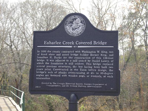
Text:
Euharlee Creek Covered Bridge
In 1886 the county contracted with Washington W. King, son of freed
slave and noted bridge builder
Horace King, and Jonathan H. Burke for the construction of this
138-foot bridge. It was adjacent to
a mill owned by Daniel Lowry, of which the foundation is still
evident. This bridge replaced several
previous structures, the last having been built two years prior.
Constructed in the Town lattice
design, the bridge's web of planks crisscrossing at 45-to 60-degree
angles are fastened with wooden
pegs, or trunnels, at each intersection.
Erected by The Georgia Historical Society, Georgia Department of Transportation,
and the Federal Highway Administration.
Located in the historic district of the city of Euharlee.