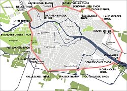
Berlin's
Brandenburg Gate is now nothing more than the inner-city border between the boroughs of Berlin-Mitte and Berlin-Tiergarten, but it has an incredible history as a border crossing. Since 1737, when a Prussian king built a wooden city wall around Berlin, this location was first a custom check point, then a border between two German provinces and then, after World War Two, a checkpoint between the Russian and the British sector of Berlin.
Ironically, the gate became most famous during the 28 years of the Berlin Wall - the only time of its 250+ years of history, when crossing this border was not possible.

|
Customs Gate, 1737
In 1737, Prussian king Frederick William I built the Berlin City Wall to enable the collection of taxes from anybody entering the city. While the city grew, the wall was shifted several times, but Brandenburg Gate, the official entrance to the city for travelers coming from the town of Brandenburg remained a custom checkpoint until 1870.
|
|
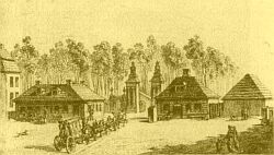
Old Gate, 1737-1788
The city wall was shifted the first time in 1788. Until then, there was only a wooden gate as seen here in a 1764 picture. |
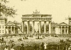 |
Brandenburg Gate, since 1791
In 1791, Prussian king Frederick William II ordered architect Carl Gotthard Langhans to build a new gate which was completed in 1791.
Here is one of the oldest pictures of the gate, dating back to 1860. Note the two smaller buildings to the left and the right of the gate: those were the quarters for the custom officers. |
Fees were collected at the gate until the foundation of the German Reich in 1871. From 1871 until 1920, Berlin was part of the German province of Brandenburg-Prussia. In 1920, Berlin became an independent city and the gate was once again a border, now between the German Capital District and the province Brandenburg-Prussia.
|
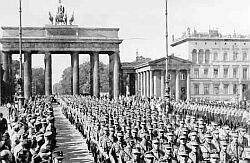 |
Berlin's Darkest Hour, 1933-1945
The march of Nazi Storm Troupers through the Gate in 1935 marked the beginning of the end for Berlin. Only ten years later, the town, the country and large parts of the world were in rubble and an iron curtain came down, dividing the town, the country and large parts of the world for decades. |
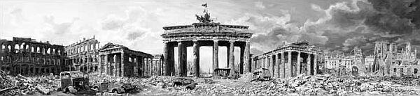
Brandenburg Gate at the End of World War II; Oil Painting by Marcel Backhaus
You Are Leaving The American Sector, 1945-1961
At the end of WW II, Berlin was divided into four sectors. While most of the historical focus is on the border between the Soviet and American sectors (see Checkpoint Charlie), the Brandenburg Gate was actually the most famous border crossings between the Soviet and the British sector. (Unfortunately, I counldn't find any "You are leaving the British sector" signs.) Though crossing the line was discouraged by Soviet and East German authorities, it was legal until the building of the Berlin Wall and for many East Germans, the Gate was the gateway to freedom. The picture above, taken a day before the Wall was built, shows that crossing the line between the systems was a common event.
All that was about to change:
The Wall, 1961-1989
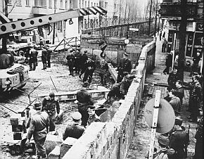 Building of the Wall, Aug. 13, 1961
 |
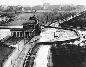 The Wall at Brandenburg Gate, 1961-1989
|
On August 13, 1961, Russian and East German troops blocked all entrances to the Western Sectors of Berlin. In the following days, the infamous
Berlin Wall was erected, dividing the city for the next 23 years and denying border crossings at the Brandenburg Gate.
On November 9, 1989, East Germany's peaceful revolution brought the Wall down and one of the first places re-opened for crossing was the Brandenburg Gate. As a matter of fact, the first people crossed the border here in the night of Nov. 9, simply by climbing the Wall.
German Reunification, 1990
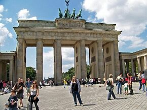
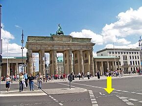
Technically, East- and West Germany remained independent states with separate seats in the United Nations until German Reunification on October 3, 1990. So, for 11 months, the Brandenburg Gate was actually a Border Crossing between two sovereign states. After reunification, this former Border between two worlds became a simple crossing between two boroughs and nobody was sad about that. Today, only a line of bricks indicates the location of a wall that once divided the world.
In August 2007, we - Volker, born in East Germany and Judy, born in California celebrated 270 years of exiting German history and crossed the "border" between Berlin-Mitte and Berlin-Tiergarten without anybody collecting taxes or shooting at us.
Judy on the eastern side of the gate |
This is where the wall used to be
|