Cape Creek Bridge No. 01113 - Lane County, Oregon
Posted by: Groundspeak Premium Member TheBeanTeam
N 44° 08.070 W 124° 07.420
10T E 410114 N 4887425
The Cape Creek Bridge was listed on the National Register on August 5th of 2005.
Waymark Code: WM21YP
Location: Oregon, United States
Date Posted: 08/21/2007
Published By:Groundspeak Premium Member silverquill
Views: 22

Designed by Conde B. McCullough the Cape Creek bridge is unique in that it crosses the creek at this location and immediately enters a tunnel through the "Devils Elbow". The bridge design bring to mind the aqueducts of the Roman Empire. At 619-feet in height The main span of the structure is a 220-foot open spandrel rib-type reinforced concrete deck arch. The Cape Creek Bridge was constructed by John K. Holt and the Clackamas Construction Company.
Source: Oregon Dept. of Transportation

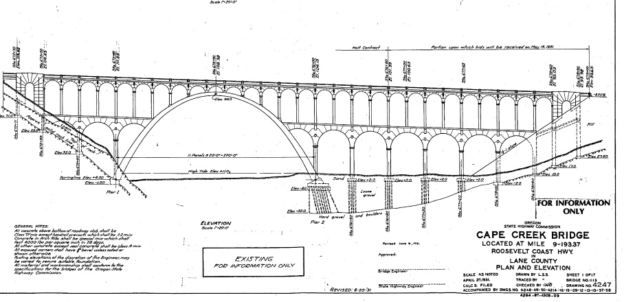
Plan Source: National Register Submission Form PDF

Bridgemeister.com has some excellent photos of the bridge and its details.

Just below the HECETA HEAD LIGHTHOUSE and just north of the crook of headland named Devils Elbow is a parking area beneath the Cape Creek Bridge. Coordinates for this waymark are at this location. Parking is available at the site but it does require a $3.00 fee or a State Parks Pass. There is a hiking trail of 1/2 mile at this location up to the lighthouse and over 7 additional miles of trail around the area. The Cape Creek Bridge and Tunnel were engineering marvels of the day and the bridge is listed on the National Register of Historic Places.

Heceta Head State Park is open to picnicking, surfing, hiking, fishing, and lighthouse tours. The lighthouse keepers house is now a bed and breakfast and is available for overnight stays.

Don Bain's Virtual Guidebook to the Oregon Coast shows a 360 degree panorama view of this location from the center of the Cape Creek Bridge including a view looking south into the tunnel at the end of the bridge.

Street address:
92072 Hwy. 101 South
Heceta Beach, Lane County
Yachats, Oregon USA
97498


County / Borough / Parish: Lane County

Year listed: 2005

Historic (Areas of) Significance: Event, Architecture/Engineering

Periods of significance: 1932-Present

Historic function: Transportation

Current function: Transportation

Privately owned?: no

Primary Web Site: [Web Link]

Secondary Website 1: [Web Link]

Season start / Season finish: Not listed

Hours of operation: Not listed

Secondary Website 2: Not listed

National Historic Landmark Link: Not listed

Visit Instructions:
Please give the date and brief account of your visit. Include any additional observations or information that you may have, particularly about the current condition of the site. Additional photos are highly encouraged, but not mandatory.
Search for...
Geocaching.com Google Map
Google Maps
MapQuest
Bing Maps
Nearest Waymarks
Nearest U.S. National Register of Historic Places
Nearest Geocaches
Create a scavenger hunt using this waymark as the center point
Recent Visits/Logs:
Date Logged Log User Rating  
kilroy18 visited Cape Creek Bridge No. 01113 - Lane County, Oregon 07/03/2019 kilroy18 visited it
The A-Team visited Cape Creek Bridge No. 01113 - Lane County, Oregon 06/12/2019 The A-Team visited it
kJfishman visited Cape Creek Bridge No. 01113 - Lane County, Oregon 09/30/2018 kJfishman visited it
ddtfamily visited Cape Creek Bridge No. 01113 - Lane County, Oregon 08/14/2013 ddtfamily visited it
Queens Blessing visited Cape Creek Bridge No. 01113 - Lane County, Oregon 06/01/2013 Queens Blessing visited it
Volcanoguy visited Cape Creek Bridge No. 01113 - Lane County, Oregon 05/20/2013 Volcanoguy visited it
TheBeanTeam wrote comment for Cape Creek Bridge No. 01113 - Lane County, Oregon 08/27/2007 TheBeanTeam wrote comment for it

View all visits/logs