|
 Butler Diamond, Butler, Pennsylvania Posted by:  JimmyEv JimmyEv
N 40° 51.504 W 079° 53.699
17T E 593133 N 4523625
Beautifully landscaped and surrounded on three sides by historic structures, including the Butler County Courthouse and the Butler County National Bank Building, Butler’s Diamond forms a pleasant courthouse square.
Waymark Code: WM1YCC
Location: Pennsylvania, United States
Date Posted: 08/02/2007
Views: 50
|
The original survey of Butler dates to 1803. In that survey, the site of the county courthouse was designated, as well as land opposite the courthouse for ‘the Diamond,’ or the town square. The Diamond has been a focal point of community activity ever since. War monuments and memorials, from the Civil War to Iraq, have been placed on the Diamond. There is also a marker commemorating the Jeep, the first one of which was manufactured in Butler.
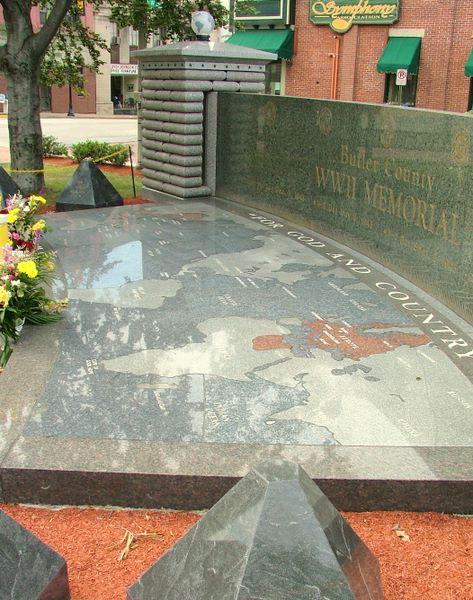
The most unusual memorial on the Diamond is the black-granite World War II Memorial. A map of the world, identifying countries involved in the war, is surrounded by a curving wall, made of sacks resembling a field-made bunker and topped by eagles.
|
Name: The Diamond

Street Location: Diamond and Main Streets
Local Municipality: City of Butler
State/Province, etc.: Pennsylvania
Country: USA
Memorial/Commemoration: Yes.
Date Established: 1803
Picnic Facilities: None.
Recreational Facilities:
None.
Monuments/Statues: Yes.
Art (murals/sculpture, etc.): Yes.
Fountains: Yes.
Ponds/Lakes/Streams/Rivers/Beach: No.
Special Events: Yes.
Web Site: Not listed
Traditional Geocaches: Not listed
|
Visit Instructions:
One photo of the park that is a different view from the one on the page, and give the date and description your visit.
Add any additional information that you may have about this park. A GPSr photo is NOT required.
|