
Knight's Ferry Markers at Hwy 120
N 37° 48.788 W 120° 39.566
10S E 706030 N 4187662
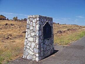
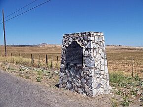
Two markers on both lanes of hwy 120 pointing towards Knight's Ferry.
Waymark Code: WM1Q9H
Location: California, United States
Date Posted: 06/22/2007
Views: 73
Here is the rare case of two markers with the same number and the same dedication on two sides of the highway.
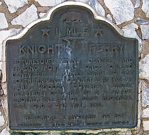
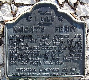
Marker 347 refers to the historic town of
Knight's Ferry. The town is located 1.4 miles west of hwy 120 but the markers are on the highway. The at this part of the highway, the lanes ate divided and the California Department of Public Works, which dedicated the markers, made sure that everybody can see it by placing markers on both lanes. The top-coordinates are half way between both markers, further down you can find the exact location of both plaques.
|
Marker on Westbound Lane |
Marker on Eastbound Lane |
|
N 37° 49.060' W 120° 39.179' |
N 37° 48.517' W 120° 39.952' |
 |
 |
 |
 |
Here is the official COHP description:
Once called Dentville, this picturesque mining center and trading post was founded in 1849. An early ferry carried Argonauts on their way to the southern mines. The rare wooden covered bridge, reportedly designed by U. S. Grant, brother-in-law of the Dent brothers, and the old flour mill were built there in 1854. The town served as the county seat from 1862 to 1872.
I recently disovered the ultimated guide to ALL California Historic Markers, the book Discover Historic California by George and Jan Roberts. It has a detailed listing of all 1,034 official historical markers. Here is what it has to say about this one:
William Knight emigrated to California with the Workman-Rowland Party, in 1841, and established a ferry operation north of Sacramento two years later. In 1848, he started the first ferry crossing of the Stanislaus River, providing prospectors access to the rich claims to be found along the river. Killed in a gunfight a year later, his operations were taken over by the Dent brothers, who built a covered bridge, sawmill and gristmill. both were rebuilt and can be seen today., the Dent house, iron jail house , Masonic Hall and general store (the oldest continously operated store in the state) are among the gold rush period structures that can be seen in town.