
Parc de la Citadelle
Posted by:  Chris777
N 48° 34.508 E 007° 46.422
32U E 409545 N 5380952
[FR] Un parc à l'est de Strasbourg, aménagé sur les restes de la citadelle.
[ENG] A park in the east of Strasbourg, arranged on the vestiges of the citadel.
Waymark Code: WM1CDG
Location: Grand-Est, France
Date Posted: 04/03/2007
Views: 137

[FR] Après la capitulation de Strasbourg en 1681, Vauban est chargé de porter des améliorations aux défenses de la ville et d'assurer le contrôle du stratégique pont du Rhin : la citadelle fut créée.
Son rôle était double : à la fois cité militaire et dernier point de défense en cas d'attaque de la cité.
A l'issue du conflit de 1870 et du siège de la ville, la fortification est démantelée.
Du plan pentagonal bastionné élaboré par les ingénieurs Tarade et Filet ne subsistent aujourd'hui que deux bastions, la courtine (muraille) les reliant, deux portes, une demi-lune.
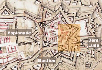
L'illustration ci-jointe vous permet de vous faire une idée de l'implantation de la Citadelle par rapport à Strasbourg : véritable cité autonome, la fortification de Vauban était reliée à Strasbourg par une courtine ; une vaste esplanade (d'où le nom du quartier actuel) séparait la ville de la Citadelle et servait à la fois de place d'arme et de zone découverte nécessaire à la défense.
Ce n'est qu'en 1967 que la friche militaire est aménagée en parc par le paysagiste Joffret.
Pour en savoir plus sur la technique du bastionnement,
cliquez ici.
[ENG] After the surrender of Strasbourg in 1681, Vauban (a famous french military architect) is charged to improve the defences of the city and to assure the control of the Rhine strategic bridge : the citadel was created.
Its role was double: at the same time military place and last defense point in the event of attack of the city. At the end of the conflict of 1870 and seat of the city, the fortification was dismantled.
Of the pentagonal bastioned plan worked out by the engineers Tarade and Filet nothing remains today except two bastions, the curtain (wall) connecting them, two doors, a half-moon.
The illustration attached enable you to have an idea of the establishment of the Citadel compared to Strasbourg : true autonomous city, the Vaubans’fortification was connected to Strasbourg by a curtain ; a vast esplanade (from where the name of the present district) separated the city from the Citadel and was used at the same time as a fencing place and open zone necessary for defence. It was only in 1967 that the military waste land was arranged as a park by the landscape designer Joffret.