 view gallery view gallery NE105.9 km NE105.9 km
|   E. L. Patton Yukon River Bridge -- Dalton Hwy, Yukon-Koyokuk Borough, AK USA E. L. Patton Yukon River Bridge -- Dalton Hwy, Yukon-Koyokuk Borough, AK USA
in Plank Roads This bridge carrying the Dalton Highway over the Yukon River is made of planks, which are more durable than asphalt or concrete in this extreme Arctic environment posted by:  Benchmark Blasterz Benchmark Blasterz location: Alaska date approved: 11/30/2022 last visited: 12/01/2022 |
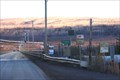
 view gallery view galleryNE105.9 km |  E. L. Patton Yukon River Bridge -- Dalton Hwy, Yukon-Koyokuk Borough, AK USA E. L. Patton Yukon River Bridge -- Dalton Hwy, Yukon-Koyokuk Borough, AK USA
in Solar Power A small solar array panel on the EL Patton bridge over the Yukon River powers lights on the bridge posted by: Benchmark Blasterz location: Alaska date approved: 11/30/2022 last visited: 12/01/2022 |
 view gallery view galleryNE106.7 km |  Yukon River Camp Truck Stop -- Yukon-Koyukuk Borough, AK USA Yukon River Camp Truck Stop -- Yukon-Koyukuk Borough, AK USA
in Truck Stops There are a few places along the Dalton Highway to stop for food or fuel. The Yukon River Camp truck stop is the second of three places on this Arctic Highway to gas up posted by: Benchmark Blasterz location: Alaska date approved: 11/30/2022 last visited: 03/01/2023 |
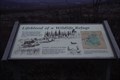 view gallery view gallery N151.3 km N151.3 km
|  Lifeblood of a Wildlife Refuge -- Finger Mountain, Yukon-Koyukuk Borough, AK USA Lifeblood of a Wildlife Refuge -- Finger Mountain, Yukon-Koyukuk Borough, AK USA
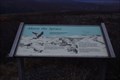
in Flora and Fauna Information Signs Second of three flora and fauna signs at the Finger Mountain landmark along the Dalton Highway. posted by: Benchmark Blasterz location: Alaska date approved: 11/30/2022 last visited: 12/01/2022 |
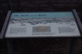 view gallery view galleryN151.3 km | Birth of a River -- Finger Mountain, Yukon-Koyukuk Borough, AK USA in Flora and Fauna Information Signs Third of three flora and fauna signs at the Finger Mountain landmark along the Dalton Highway. posted by: Benchmark Blasterz location: Alaska date approved: 11/30/2022 last visited: 12/01/2022 |
 view gallery view galleryN151.3 km | Above the Spruce -- Finger Mountain,Yukon-Koyukuk Borough, AK USA in Flora and Fauna Information Signs One of three flora and fauna signs at the Finger Mountain landmark along the Dalton Highway. posted by: Benchmark Blasterz location: Alaska date approved: 11/30/2022 last visited: 12/01/2022 |
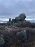 view gallery view galleryN151.3 km |  Finger Rock -- Yukon-Koyukuk Borough, AK USA Finger Rock -- Yukon-Koyukuk Borough, AK USA
in Places of Geologic Significance The granite outcrop (tor) known today as Finger Rock has been an important landmark in the Arctic tundra for thousands of years. Finger Rock is in the center of a ring of many tors, now known as Finger Mountain (even though its not a mountain). posted by: Benchmark Blasterz location: Alaska date approved: 11/30/2022 last visited: 03/01/2023 |
 view gallery view gallery SE153.4 km SE153.4 km
|  Ice Age Hunters - Denali National Park Ice Age Hunters - Denali National Park
in Alaska Historic Markers Ice age hunters flowed the Caribou trails through Denali. Located at a rest stop along the Park Road in the Denali Nation Park. See parks web site for access information. posted by:  Lat34North Lat34North location: Alaska date approved: 01/23/2014 last visited: 07/11/2016 |
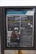 view gallery view gallerySE154.3 km | Are You Prepared? — Savage River Picnic Area, Denali Park Road MP 13, Denali National Park, AK USA in Flora and Fauna Information Signs One of three flora and fauna information signs at the Savage River picnic area in the loop trail head in Denali National Park, this one gives excellent advice about dealing with moose, bear, and wolves - which are commonly seen in the park posted by: Benchmark Blasterz location: Alaska date approved: 12/01/2022 last visited: 01/30/2023 |
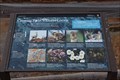 view gallery view gallerySE154.3 km | Crossing Paths with the Locals -- Savage River Picnic Area, Denali Park Road MP 13, Denali National Park, AK USA in Flora and Fauna Information Signs Second of three flora and fauna information signs at the Savage River picnic area at the Savage River Loop trailhead in Denali National Park, this sign identifies local plants and animals commonly seen in this area posted by: Benchmark Blasterz location: Alaska date approved: 12/01/2022 last visited: 01/30/2023 |
 view gallery view gallerySE154.3 km | Life on a Braided River-- Savage River Picnic Area, Denali Park Road MP 13, Denali National Park, AK USA in Flora and Fauna Information Signs Third of three flora and fauna information signs at the Savage River picnic area in the loop trail head in Denali National Park posted by: Benchmark Blasterz location: Alaska date approved: 12/01/2022 last visited: 01/30/2023 |
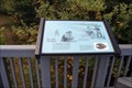
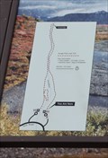 view gallery view gallerySE154.3 km |  YAH -- Savage River Loop Trailhead, Denali Park Road MP 13, Denali National Park, AK USA YAH -- Savage River Loop Trailhead, Denali Park Road MP 13, Denali National Park, AK USA
in 'You Are Here' Maps A You are Here map at the Savage River Loop Trailhead at Denali National Park posted by: Benchmark Blasterz location: Alaska date approved: 12/01/2022 last visited: 01/30/2023 |
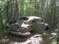 view gallery view gallery S155.9 km S155.9 km
|  The Getaway Car, Houston, Alaska The Getaway Car, Houston, Alaska
in Abandoned Dead Vehicles We were lured to this wooded area by a geocache and found this most intriguing car there. posted by: Queens Blessing location: Alaska date approved: 07/28/2010 last visited: 09/15/2012 |
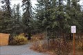 view gallery view gallerySE157.1 km |  Savage Cabin Interpretive Loop Trail -- Park Road, Denali National Park, AK USA Savage Cabin Interpretive Loop Trail -- Park Road, Denali National Park, AK USA
in Hiking and walking trailheads The Savage Cabin Interpretive Loop Trailhead, along the Park Road, Denali National Park, AK USA posted by: Benchmark Blasterz location: Alaska date approved: 12/02/2022 last visited: 01/30/2023 |
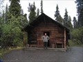 view gallery view gallerySE157.1 km |  Upper Savage River Cabin No. 30 - Denali National Park Upper Savage River Cabin No. 30 - Denali National Park
in U.S. National Register of Historic Places A stop on the Natural History Tour in Denali National Park. posted by: heringermr location: Alaska date approved: 07/19/2008 last visited: 06/16/2023 |
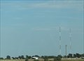 view gallery view gallerySE157.2 km |  K204GP-FM 88.7 (KRBG) & K223AU-FM 92.5 (KXLV) -- Dumas TX USA K204GP-FM 88.7 (KRBG) & K223AU-FM 92.5 (KXLV) -- Dumas TX USA
in Radio and Television Transmitter Towers The small town of Dumas, TX (home of the Ding-Dong Daddy <-- NOT MAKING THAT UP), has two low-power FM translators bringing the distant stations from Amarillo to this part of West Texas posted by: Benchmark Blasterz location: Texas date approved: 01/30/2023 last visited: 02/01/2023 |
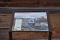
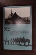 view gallery view gallerySE157.2 km | Savage Camp -- Denali Park Road, Denali National Park, AK USA in Alaska Historic Markers This historical marker is located at the trailhead shed waiting area for the Savage camp bus stop along the Park Road in Denali National Park posted by: Benchmark Blasterz location: Alaska date approved: 12/16/2022 last visited: 01/30/2023 |
|