 view gallery view gallery SE21.4 km SE21.4 km
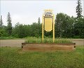
|   John Hart Hiway Traffic Webcam - Dawson Creek, BC John Hart Hiway Traffic Webcam - Dawson Creek, BC
in Web Cameras Hwy 97 (John Hart Hwy) at Mason-Semple Rd, looking east. This is a short 15 km. west of Dawson Creek. We are now all the way up into what is known as the Peace Country. posted by:  T0SHEA T0SHEA location: British Columbia, Canada date approved: 10/07/2013 last visited: 01/14/2014 |
 view gallery view gallery NW21.4 km NW21.4 km
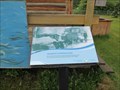
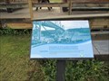
|  Waterfowl of Charlie Lake Marsh - Charlie Lake, British Columbia Waterfowl of Charlie Lake Marsh - Charlie Lake, British Columbia
in Flora and Fauna Information Signs Charlie Lake Wetland and trails is Mile 52 on the Alaska Highway, next to Rotary RV Park. posted by: T0SHEA location: British Columbia, Canada date approved: 08/06/2021 last visited: never |
 view gallery view gallery N28.6 km N28.6 km
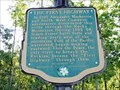
|  The First Highway - Taylor, BC The First Highway - Taylor, BC
in British Columbia Heritage Markers At the top of the South Taylor Hill, about 7 kilometres south of the Town of Taylor, is a large pullout/rest area/brake check area in which stands a very interesting British Columbia Stop of Interest marker. posted by: T0SHEA location: British Columbia, Canada date approved: 09/07/2019 last visited: never |
 view gallery view galleryN28.6 km |  FIRST - "Highway" Through the Rocky Mountains FIRST - "Highway" Through the Rocky Mountains
in First of its Kind At the top of the South Taylor Hill, about 7 kilometres south of the Town of Taylor, British Columbia is a large pullout/rest area/brake check area in which stands a very interesting British Columbia Stop of Interest marker. posted by: T0SHEA location: British Columbia, Canada date approved: 09/03/2019 last visited: never |
 view gallery view galleryN28.6 km |  ONLY - River Which Runs Through the Rocky Mountains ONLY - River Which Runs Through the Rocky Mountains
in Superlatives At the top of the South Taylor Hill, about 7 kilometres south of the Town of Taylor, British Columbia is a large pullout/rest area/brake check area in which stands a very interesting British Columbia Stop of Interest marker. posted by: T0SHEA location: British Columbia, Canada date approved: 09/02/2019 last visited: never |
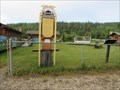
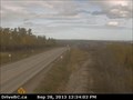 view gallery view galleryN28.6 km | South Taylor Hill Traffic Webcam - Taylor, BC in Web Cameras Hwy 97 at South Taylor Hill, 20 km south of Fort St John, across the river from Taylor. posted by: T0SHEA location: British Columbia, Canada date approved: 10/07/2013 last visited: 01/14/2014 |
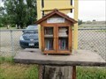
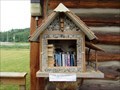 view gallery view galleryN32 km |  Free Book Exchange 2 - Taylor, British Columbia Free Book Exchange 2 - Taylor, British Columbia
in Free Community Book Exchanges Free Book Exchange 2 in Taylor is located in Peace Island Park at the Rocky Mountain Fort Museum on Big Barn Road just off Hwy.97. posted by: T0SHEA location: British Columbia, Canada date approved: 08/07/2019 last visited: never |
 view gallery view galleryN32 km | McKnight's Stopping Place - Taylor, British Columbia in British Columbia Heritage Markers McKnight's Stopping Place sign is near the canoe mural in Peace Island Park. posted by: T0SHEA location: British Columbia, Canada date approved: 09/20/2021 last visited: never |
 view gallery view galleryN32 km | Sir Alexander Mackenzie - Taylor, British Columbia in British Columbia Heritage Markers Sir Alexander Mackenzie sign is located in Peace Island Park at the Rocky Mountain Fort Museum on Big Barn Road just off Hwy.97. posted by: T0SHEA location: British Columbia, Canada date approved: 09/20/2021 last visited: never |
 view gallery view galleryN32 km | Building of the Alaska Highway - Taylor, British Columbia in British Columbia Heritage Markers Building of the Alaska Highway & Peace River Suspension Bridge sign is located in Peace Island Park at the Rocky Mountain Fort Museum on Big Barn Road just off Hwy.97. posted by: T0SHEA location: British Columbia, Canada date approved: 09/20/2021 last visited: never |
 view gallery view galleryN32 km | Trading Post - Taylor, British Columbia in British Columbia Heritage Markers Trading Post sign is at the entrance to Peace Island Park located South of Taylor and across the Peace River. It is on Boat Launch Road. posted by: T0SHEA location: British Columbia, Canada date approved: 09/20/2021 last visited: never |
 view gallery view galleryN32 km |  Trading Post - 1718 to 1995 - Taylor, British Columbia Trading Post - 1718 to 1995 - Taylor, British Columbia
in Timelines Trading Post Timeline is at the entrance to Peace Island Park located South of Taylor and across the Peace River. It is on Boat Launch Road. posted by: T0SHEA location: British Columbia, Canada date approved: 09/07/2021 last visited: never |
 view gallery view galleryN32 km | Free Book Exchange 1 - Taylor, British Columbia in Free Community Book Exchanges Free Book Exchange 1 in Taylor is located in Peace Island Park at the Rocky Mountain Fort Museum on Big Barn Road just off Hwy.97. posted by: T0SHEA location: British Columbia, Canada date approved: 08/07/2019 last visited: never |
 view gallery view galleryN32.5 km |  The Peace River - British Columbia and Alberta, Canada The Peace River - British Columbia and Alberta, Canada
in Wikipedia Entries At the top of the South Taylor Hill, about 7 kilometres south of the Town of Taylor, is a large pullout/rest area/brake check area in which stands a very interesting British Columbia Stop of Interest marker. posted by: T0SHEA location: British Columbia, Canada date approved: 09/02/2019 last visited: never |
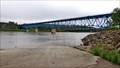
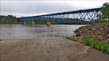 view gallery view galleryN32.5 km | Peace River Bridge - Taylor, BC in Wikipedia Entries A 649 meter (2,130 feet) deck truss bridge, this bridge was built to replace the original Alaska Highway suspension bridge which met its maker in 1957. posted by: T0SHEA location: British Columbia, Canada date approved: 07/16/2021 last visited: never |
 view gallery view galleryN32.5 km | LONGEST - Bridge on the Alaska Highway - Taylor, BC in Superlatives A 649 meter (2,130 feet) deck truss bridge, this bridge was built to replace the original Alaska Highway suspension bridge which met its maker in 1957. posted by: T0SHEA location: British Columbia, Canada date approved: 07/16/2021 last visited: never |
 view gallery view galleryN32.5 km |  Peace River Bridge - Taylor, BC Peace River Bridge - Taylor, BC
in Truss Bridges A 649 meter (2,130 feet) deck truss bridge, this bridge was built to replace the original Alaska Highway suspension bridge which met its maker in 1957. posted by: T0SHEA location: British Columbia, Canada date approved: 07/17/2021 last visited: never |
 view gallery view galleryN32.5 km |  Taylor Bridge study panel could be good news - Taylor, BC Taylor Bridge study panel could be good news - Taylor, BC
in News Article Locations A 649 meter (2,130 feet) deck truss bridge, this bridge was built to replace the original Alaska Highway suspension bridge which met its maker in 1957. posted by: T0SHEA location: British Columbia, Canada date approved: 07/16/2021 last visited: never |
 view gallery view gallery E33 km E33 km
| Dawson Creek Traffic Webcam-N - Dawson Creek, BC in Web Cameras Hiway 97 at Dangerous Goods Route, on the western edge of Dawson Creek. posted by: T0SHEA location: British Columbia, Canada date approved: 10/07/2013 last visited: 01/06/2014 |
 view gallery view galleryE33 km | Dawson Creek Traffic Webcam-W - Dawson Creek, BC in Web Cameras Hwy 97 at Dangerous Goods Route, on the western edge of Dawson Creek. posted by: T0SHEA location: British Columbia, Canada date approved: 10/07/2013 last visited: 01/06/2014 |
 view gallery view galleryE33 km | Dawson Creek Traffic Webcam-S - Dawson Creek, BC in Web Cameras Hwy 97 at Dangerous Goods Route, on the western edge of Dawson Creek. posted by: T0SHEA location: British Columbia, Canada date approved: 10/07/2013 last visited: 01/06/2014 |
 view gallery view gallery SW33 km SW33 km
| East Pine Hill Traffic Webcam - Chetwynd, BC in Web Cameras Hwy 97 on East Pine Hill, about 27 km east of Chetwynd, at Chetwynd Pulp Mill Road, looking east. posted by: T0SHEA location: British Columbia, Canada date approved: 10/07/2013 last visited: 01/08/2014 |
 view gallery view galleryE33.2 km | Dawson Creek Traffic Webcam-E - Dawson Creek, BC in Web Cameras Hwy 97 at Dangerous Goods Route, on the western edge of Dawson Creek. posted by: T0SHEA location: British Columbia, Canada date approved: 10/07/2013 last visited: 01/06/2014 |
 view gallery view galleryE34 km |  Mile 0 Campground, Dawson Creek, British Columbia Mile 0 Campground, Dawson Creek, British Columbia
in Campgrounds Mile 0 Campground in Dawson Creek is just off the Alaska Hwy./97 Hwy. slightly north of downtown. posted by: T0SHEA location: British Columbia, Canada date approved: 07/23/2019 last visited: never |
 view gallery view galleryE34 km |  Mile "0" Park Playground - Dawson Creek, British Columbia Mile "0" Park Playground - Dawson Creek, British Columbia
in Public Playgrounds Mile "0" Park is located on Haer Hwy. and 20th Street. posted by: T0SHEA location: British Columbia, Canada date approved: 07/23/2021 last visited: never |
|