 view gallery view gallery SW19.6 km SW19.6 km
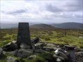
|   Sawel, Sperrin Mountains, Co. Derry Sawel, Sperrin Mountains, Co. Derry
in U.K. and Ireland Trigpoints Trig Pillar at the summit of Sawel Mountain (678m) posted by:  dino-irl dino-irl location: Ireland date approved: 10/29/2007 last visited: 07/13/2009 |
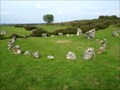 view gallery view gallerySW24.3 km |  Beaghmore - Northern Ireland Beaghmore - Northern Ireland
in Wikipedia Entries Beaghmore is a complex of early Bronze Age megalithic features, stone circles and cairns, 8.5 miles north west of Cookstown, County Tyrone in Northern Ireland. posted by:  Noe1 Noe1 location: Ulster, Ireland date approved: 11/04/2014 last visited: 06/03/2021 |
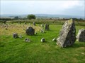 view gallery view gallerySW24.3 km |  Beaghmore Stone Circles - Northern Ireland Beaghmore Stone Circles - Northern Ireland
in Megalithic Monuments Beaghmore is a complex of early Bronze Age megalithic features, stone circles and cairns, 8.5 miles north west of Cookstown, County Tyrone in Northern Ireland. posted by: Noe1 location: Ulster, Ireland date approved: 11/04/2014 last visited: 06/03/2021 |
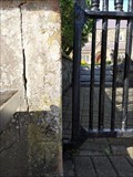 view gallery view gallery N26.6 km N26.6 km
| Cut Mark St Patrick's Church Gate, Coleraine, Northern Ireland in U.K. and Ireland Trigpoints St Patrick's Church of Ireland is in the town centre. posted by: elyob location: Ulster, Ireland date approved: 04/24/2022 last visited: 07/08/2023 |
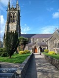 view gallery view galleryN26.6 km |  St. Patrick's Church - Coleraine, Northern Ireland St. Patrick's Church - Coleraine, Northern Ireland
in Anglican and Episcopal Churches St. Patrick's Church of Ireland is in the town centre. posted by: elyob location: Ulster, Ireland date approved: 05/20/2022 last visited: 07/08/2023 |
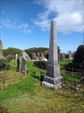 view gallery view galleryN33 km |  Black Family Obelisk - Old Graveyard, Ballywillan, Northern Ireland Black Family Obelisk - Old Graveyard, Ballywillan, Northern Ireland
in Obelisks The Old Graveyard at Ballywillan is near Portrush. posted by: elyob location: Ulster, Ireland date approved: 05/03/2022 last visited: never |
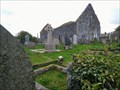 view gallery view galleryN33.2 km |  Ballywillan Church Ruins - Ballywillan, Portrush, Northern Ireland Ballywillan Church Ruins - Ballywillan, Portrush, Northern Ireland
in Medieval Churches From many areas in the town of Portrush, the church ruins can be seen on the high ground to the south. posted by: elyob location: Ulster, Ireland date approved: 06/04/2022 last visited: never |
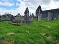 view gallery view galleryN33.2 km |  Old Graveyard, Ballywillan, near Portrush, Northern Ireland Old Graveyard, Ballywillan, near Portrush, Northern Ireland
in Worldwide Cemeteries Posted co-ordinates are for the only entrance to the old graveyard. It is a gate on the south side of Magheraboy Road. posted by: elyob location: Ulster, Ireland date approved: 04/30/2022 last visited: never |
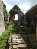 view gallery view galleryN33.2 km |  Ballywillan Church Ruins - Ballywillan, near Portrush, Northern Ireland Ballywillan Church Ruins - Ballywillan, near Portrush, Northern Ireland
in Preserved Architectural Remnants and Ruins Use the car park at the modern cemetery. posted by: elyob location: Ulster, Ireland date approved: 05/10/2022 last visited: never |
 view gallery view galleryN33.2 km | Ballywillan Cemetery, near Portrush, Northern Ireland in Worldwide Cemeteries The main gate (no longer available to vehicles) is on Magheraboy Road. posted by: elyob location: Ulster, Ireland date approved: 04/29/2022 last visited: never |
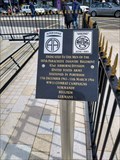 view gallery view galleryN34.6 km |  507th Parachute Infantry Regiment Memorials - Portrush, Northern Ireland 507th Parachute Infantry Regiment Memorials - Portrush, Northern Ireland
in World War II Memorials / Monuments The two plaques are beside the Portrush War Memorial on the town hall green. posted by: elyob location: Ulster, Ireland date approved: 05/02/2022 last visited: never |
 view gallery view galleryN34.6 km |  War Memorial, Portrush, Northern Ireland War Memorial, Portrush, Northern Ireland
in World War I Memorials and Monuments This war memorial is the main feature on the town hall green. posted by: elyob location: Ulster, Ireland date approved: 05/01/2022 last visited: never |
 view gallery view gallery NE35.9 km NE35.9 km
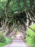
|  Dark Hedges - County Antrim, Northern Ireland. Dark Hedges - County Antrim, Northern Ireland.
in Picture Perfect Postcards The Dark Hedges is an avenue of Beech Trees forming a dark creepy tunnel. The location was used in the TV series Game of Thrones.
Located in Dark Hedges, Ballymoney, County Antrim, Northern Ireland, United Kingdom. posted by: veritas vita location: United Kingdom date approved: 07/20/2018 last visited: 07/09/2021 |
 view gallery view galleryNE35.9 km | Dark Hedges - Ballymoney, County Antrim, Northern Ireland. in Wikipedia Entries The Dark Hedges is an avenue of Beech Trees forming a dark creepy tunnel. The location was used in the TV series Game of Thrones. Located in Dark Hedges, Ballymoney, County Antrim, Northern Ireland, United Kingdom. posted by: veritas vita location: United Kingdom date approved: 07/23/2018 last visited: 07/09/2021 |
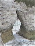 view gallery view galleryN36.2 km |  Magheracross Arch - County Antrim, Northern Ireland. Magheracross Arch - County Antrim, Northern Ireland.
in Natural Arches The viewpoint at Magheracross - Affords visitors, ever changing views of White Cliffs Arch. & the crashing Atlantic waves. The car park lies between Portrush & Bushmills, & gives photographers great photos of the Northern Irish Coast. posted by: veritas vita location: United Kingdom date approved: 06/24/2018 last visited: 07/18/2023 |
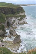 view gallery view galleryN36.2 km |  Magheracross Viewpoint - County Antrim, Northern Ireland, U.K. Magheracross Viewpoint - County Antrim, Northern Ireland, U.K.
in Wavy Places The viewpoint at Magheracross - Affords visitors, ever changing views of Whiterock cliffs. & the crashing Atlantic waves. The car park lies between Portrush & Bushmills, & gives photographers great photos of the Northern Irish Coast. posted by: veritas vita location: South Wales, United Kingdom date approved: 06/24/2018 last visited: 01/22/2022 |
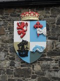 view gallery view galleryN36.5 km |  MacDonnell of Antrim Coat of Arms - County Antrim, Northern Ireland MacDonnell of Antrim Coat of Arms - County Antrim, Northern Ireland
in Coats of Arms This coat of arms for the MacDonnell of Antrim is located at Dunluce Castle in County Antrim in Northern Ireland. posted by: Marine Biologist location: United Kingdom date approved: 08/03/2012 last visited: 06/13/2018 |
 view gallery view galleryN36.5 km |  Dunluce Castle - Satellite Oddity - Northern Ireland, United Kingdom. Dunluce Castle - Satellite Oddity - Northern Ireland, United Kingdom.
in Satellite Imagery Oddities Dunluce Castle - A Medieval Irish Castle - Featured on Virtual Globetrotting the Satellite Oddity website. The Castle surrounded by very steep drops. Now a protected Monument in State care. Located on the County Antrim Coast, Northern Ireland, UK. posted by: veritas vita location: United Kingdom date approved: 06/21/2018 last visited: 07/10/2021 |
 view gallery view galleryN36.5 km |  Dunluce Castle - County Antrim, Northern Ireland. Dunluce Castle - County Antrim, Northern Ireland.
in UK Historical Markers Dunluce Castle - A Medieval Irish Castle standing on a stony outcrop, surrounded with very steep drops. Now a protected Monument, in State care. Located on the County Antrim Coast, Northern Ireland, United Kingdom. posted by: veritas vita location: United Kingdom date approved: 10/29/2018 last visited: 08/16/2019 |
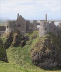 view gallery view galleryN36.5 km | Dunluce Castle - Ruin - Antrim Coast, Northern Ireland. in Preserved Architectural Remnants and Ruins Dunluce Castle - A Medieval Irish Castle standing on a stony outcrop, surrounded with very steep drops. Now a protected Monument, in State care. Located on the County Antrim Coast, Northern Ireland, United Kingdom. posted by: veritas vita location: United Kingdom date approved: 06/21/2018 last visited: 07/10/2021 |
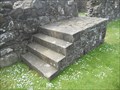 view gallery view galleryN36.5 km |  Dunluce Castle Carriage Block - County Antrim, Northern Ireland Dunluce Castle Carriage Block - County Antrim, Northern Ireland
in Historic Upping Stones, Hitching Posts, and Carriage Blocks Dunluce Castle is a medieval castle situated in County Antrim in Northern Ireland. The audio tour pointed out this mounting block just outside the castle's Stables and Harness Room. posted by: Marine Biologist location: United Kingdom date approved: 06/30/2012 last visited: 06/13/2018 |
 view gallery view galleryN36.5 km |  Dunluce Castle - Tourism Attraction - Northern Ireland, United Kingdom. Dunluce Castle - Tourism Attraction - Northern Ireland, United Kingdom.
in Official Local Tourism Attractions Dunluce Castle - A Medieval Irish Castle standing in ruin on a stony outcrop, surrounded with very steep drops. Now a listed protected Monument, in State care. Located on the County Antrim Coast, Northern Ireland, United Kingdom. posted by: veritas vita location: United Kingdom date approved: 06/21/2018 last visited: 07/10/2021 |
 view gallery view galleryN36.5 km | Dunluce Castle - County Antrim, Northern Ireland in Wikipedia Entries Dunluce Castle is a medieval castle situated in County Antrim in Northern Ireland. posted by: Marine Biologist location: United Kingdom date approved: 06/30/2012 last visited: 07/10/2021 |
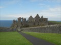 view gallery view galleryN36.5 km |  Dunluce Castle - County Antrim, Northern Ireland Dunluce Castle - County Antrim, Northern Ireland
in Castles Dunluce Castle is a medieval castle situated in County Antrim in Northern Ireland. posted by: Marine Biologist location: United Kingdom date approved: 06/30/2012 last visited: 07/10/2021 |
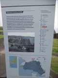
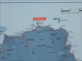 view gallery view galleryN36.5 km |  You Are Here - Dunluce Castle - County Antrim, Northern Ireland You Are Here - Dunluce Castle - County Antrim, Northern Ireland
in 'You Are Here' Maps Two You Are Here maps are located on a sign at the entrance to Dunluce Castle: one showing the location of the castle in relation to the castle's visitor center and one showing the castle in relation to the Causeway Coastal Route. posted by: Marine Biologist location: United Kingdom date approved: 07/30/2012 last visited: 08/14/2018 |
|