 view gallery view gallery E8 km E8 km
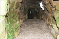
|   Finnis Souterrain Finnis Souterrain
in Megalithic Monuments Finnis Souterrain, locally known as ‘Binder’s Cove,’ is a hidden gem for the intrepid heritage enthusiast. posted by:  Windsocker Windsocker location: Ireland date approved: 04/13/2008 last visited: never |
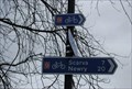
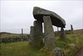 view gallery view galleryE9.5 km | Legananny Dolmen in Megalithic Monuments Legananny Dolmen is situated off the B7 7 miles south of Dromara, signposted from Dromara and Castlewellan. There is no entrance free and visitors are welcome to visit Legananny Dolmen all year round.
posted by: Windsocker location: Ireland date approved: 04/13/2008 last visited: 03/12/2003 |
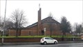
 view gallery view gallery N12.6 km N12.6 km
|  Subway - Hillsborough, County Down, Northern Ireland Subway - Hillsborough, County Down, Northern Ireland
in Subway Restaurants from A1 southbound posted by: elyob location: Ulster, Ireland date approved: 05/11/2022 last visited: never |
 view gallery view gallery W12.9 km W12.9 km
|  Salmon - Scarva Ireland Salmon - Scarva Ireland
in Outside Wooden Display Carvings A wooden carving of a Salmon located in the historic and picturesque village of Scarva North Ireland posted by: Windsocker location: Ireland date approved: 03/02/2008 last visited: 08/21/2021 |
 view gallery view galleryW12.9 km |  Royal Ulster Constabulary - Scarva Northern Ireland Royal Ulster Constabulary - Scarva Northern Ireland
in Police Memorials This is a memorial to four officers of the RUC in Scarva Northern Ireland. posted by: Windsocker location: Ulster, Ireland date approved: 03/02/2008 last visited: never |
 view gallery view gallery SE15.8 km SE15.8 km
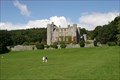
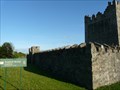
|  Castlewellan Castle Castlewellan Castle
in Castles It was during the lifetime of the fourth Earl, in 1856, that the present Castle was built. When he died unmarried in 1874 he was succeeded by his brother, Hugh. posted by: Bebop location: Ireland date approved: 09/22/2006 last visited: 08/17/2018 |
 view gallery view gallery S18.3 km S18.3 km
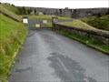
|  The Magic Road, Spelga Dam, Co. Down The Magic Road, Spelga Dam, Co. Down
in Vortexes, Mystery Spots, and Gravity Hills A road that apparently defies gravity, where objects roll "uphill". posted by: el-dorito location: Ulster, Ireland date approved: 08/16/2009 last visited: never |
 view gallery view gallery SW18.5 km SW18.5 km
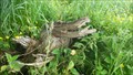
|  Hungry Gator in Down, Ulster - Ireland Hungry Gator in Down, Ulster - Ireland
in Simulacra Beware of the Croc posted by: MoVeD location: Ulster, Ireland date approved: 06/29/2015 last visited: 06/29/2015 |
 view gallery view gallery NW20.4 km NW20.4 km
|  Cycle Route 9 - Potadown Northern Ireland Cycle Route 9 - Potadown Northern Ireland
in Cycling Routes This cycle and walking route from the Bann Bridge in Portadown to the Town Hall in Newry is a 20 mile trip on part of route 9 of the National Cycle Network. The route follows the towpath on the western bank of the, now non-navigable, Newry Canal. posted by: Windsocker location: Ireland date approved: 03/03/2008 last visited: 03/15/2022 |
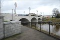 view gallery view galleryNW20.4 km |  Bann River Bridge - Portadown Northern Ireland Bann River Bridge - Portadown Northern Ireland
in Arch Bridges The bridge carries around 21,000 vehicles each day and, due to its town centre location, is very important to the commercial and business life of Portadown.
posted by: Windsocker location: Ireland date approved: 03/02/2008 last visited: 08/05/2011 |
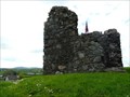 view gallery view galleryE21.9 km | Clough Castle - Clough, Northern Ireland in Castles Clough Castle is the site of an Anglo-Norman Motte-and-bailey situated in Clough, County Down, Northern Ireland posted by: tmob location: Ulster, Ireland date approved: 02/03/2012 last visited: never |
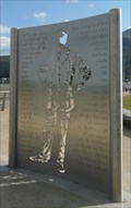 view gallery view gallerySE22.5 km |  Percy French Memorial - Newcastle, Northern Ireland Percy French Memorial - Newcastle, Northern Ireland
in Silhouette Public Art Sculptures Percy French Memorial in Newcastle's promenade posted by: tmob location: Ulster, Ireland date approved: 02/10/2011 last visited: never |
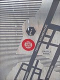 view gallery view gallerySE22.5 km |  You Are Here - Newcastle Centre, Newcastle, Northern Ireland You Are Here - Newcastle Centre, Newcastle, Northern Ireland
in 'You Are Here' Maps The curved metal sign is in front of the tourist information centre. posted by: elyob location: Ulster, Ireland date approved: 05/06/2022 last visited: never |
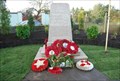
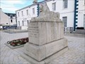 view gallery view gallerySE22.5 km |  War Memorial, Newcastle, County Down, Northern Ireland War Memorial, Newcastle, County Down, Northern Ireland
in World War I Memorials and Monuments The memorial is in front of the tourist information centre. posted by: elyob location: Ulster, Ireland date approved: 05/06/2022 last visited: never |
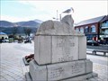 view gallery view gallerySE22.5 km |  Lion on Plinth - Newcastle, County Down, Northern Ireland Lion on Plinth - Newcastle, County Down, Northern Ireland
in Lion Statues This lion rests atop the memorial in front of the tourist information centre. posted by: elyob location: Ulster, Ireland date approved: 05/06/2022 last visited: never |
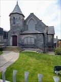 view gallery view gallerySE22.5 km |  Newcastle Methodist Church - Newcastle, County Down, Northern Ireland Newcastle Methodist Church - Newcastle, County Down, Northern Ireland
in Methodist Churches The church address is 37 Central Promenade. posted by: elyob location: Ulster, Ireland date approved: 05/04/2022 last visited: never |
 view gallery view galleryS25.7 km | Narrow Water Castle - Warrenpoint, Northern Ireland in Castles Narrow Water Castle is a famous tower house near Warrenpoint in Northern Ireland, located on the County Down bank of the Clanrye River, which enters Carlingford Lough a mile to the south. posted by: tmob location: Ulster, Ireland date approved: 02/03/2012 last visited: 05/29/2021 |
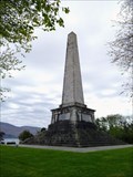 view gallery view galleryS26.2 km |  Ross Monument - Rostrevor, County Down, Northern Ireland Ross Monument - Rostrevor, County Down, Northern Ireland
in War of 1812 The car park is on the south side of busy Warrenpoint Road. The monument is to the north. posted by: elyob location: Ulster, Ireland date approved: 05/04/2022 last visited: never |
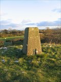 view gallery view galleryW28.2 km |  Vicars Cairn Trig - Co Armagh Vicars Cairn Trig - Co Armagh
in U.K. and Ireland Trigpoints A trig pillar located on top of Vicars Cairn Co Armagh posted by: Windsocker location: Ireland date approved: 12/19/2008 last visited: never |
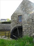 view gallery view gallerySE30.6 km |  Annalong Cornmill - Annalong, Northern Ireland Annalong Cornmill - Annalong, Northern Ireland
in Water Mills Annalong Harbour is one of Ireland's most picturesque harbours, with its cornmill, built about 1830 and powered by a waterwheel. It operated until the 1960s, being one of Ulster's last working watermills. posted by: tmob location: United Kingdom date approved: 03/17/2011 last visited: 04/24/2011 |
 view gallery view gallery NE30.9 km NE30.9 km
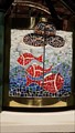
|  Fishes & Loaves - St Brigid's Church - Belfast Fishes & Loaves - St Brigid's Church - Belfast
in Mosaics A small mosaic on the altar of St Brigid's church, Belfast. posted by: SMacB location: Ulster, Ireland date approved: 02/05/2017 last visited: never |
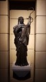 view gallery view galleryNE30.9 km |  St Brigid - St Brigid's Church - Belfast St Brigid - St Brigid's Church - Belfast
in Statues of Religious Figures A bronze figure of St Brigid in St Brigid's church, Belfast. posted by: SMacB location: Ulster, Ireland date approved: 02/06/2017 last visited: never |
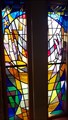 view gallery view galleryNE30.9 km |  Stained Glass Windows - St Brigid's church - Belfast Stained Glass Windows - St Brigid's church - Belfast
in Stained Glass Windows Stained Glass Windows in St Brigid's church, Belfast. posted by: SMacB location: Ulster, Ireland date approved: 02/06/2017 last visited: never |
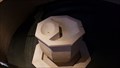 view gallery view galleryNE30.9 km |  Baptism Font - St Brigid's church - Belfast Baptism Font - St Brigid's church - Belfast
in Stone Church Artefacts Baptism font inside St Brigid's church, Derryvolgie Avenue, Belfast. posted by: SMacB location: Ulster, Ireland date approved: 02/05/2017 last visited: never |
 view gallery view galleryNE30.9 km |  St Brigid - Derryvolgie Avenue - Belfast St Brigid - Derryvolgie Avenue - Belfast
in Roman Catholic Churches St Brigid's Church, Belfast. posted by: SMacB location: Ulster, Ireland date approved: 02/05/2017 last visited: never |
|