 view gallery view gallery SE4.7 km SE4.7 km
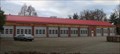
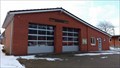
|   Freiwillige Feuerwehr Bad Bramstedt Freiwillige Feuerwehr Bad Bramstedt
in Firehouses Gerätehaus in Bad Bramstedt posted by:  CA* CA* location: Schleswig-Holstein, Germany date approved: 11/15/2009 last visited: 10/19/2017 |
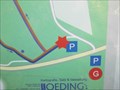
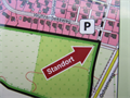
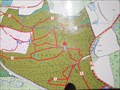
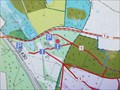
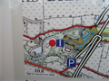 view gallery view gallerySE5.8 km |  FFH-Gebiet "Osterautal" - SH, Germany FFH-Gebiet "Osterautal" - SH, Germany
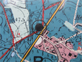
in 'You Are Here' Maps [DE] eine Karte mit dem eigenen Standort am Wanderweg im FFH-Naturschutzgrebiet Osterautal
[ENG] a map with the own location on the trail in the nature reserve "Osterautal" posted by:  EDTA EDTA location: Schleswig-Holstein, Germany date approved: 03/26/2016 last visited: 03/12/2016 |
 view gallery view gallery W6.8 km W6.8 km
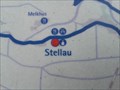
| Karte an der Kirche Stellau am Mönchsweg, SH, Germany in 'You Are Here' Maps [DE] Eine Karte mit dem eigenen Standort auf dem Mönchsweg an der Kirche Stellau.
[ENG] A map with your own location on the "Mönchsweg" at the church Stellau. posted by: EDTA location: Schleswig-Holstein, Germany date approved: 02/08/2016 last visited: 01/17/2016 |
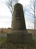
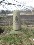 view gallery view gallerySE8.7 km |  Altona-Kieler Chaussee - Lentföhrden, SH, Germany Altona-Kieler Chaussee - Lentföhrden, SH, Germany
in Milestones [DE] Vollmeilenstein der "Altona-Kiel Chaussee" bei Lentföhrden. [ENG] milestone of "Altona-Kiel Chaussee" near Lentföhrden. posted by: EDTA location: Schleswig-Holstein, Germany date approved: 02/25/2018 last visited: never |
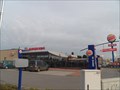
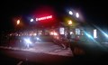 view gallery view gallery NE10.1 km NE10.1 km
|  Burger King - Brokenlande Ost - Grobenaspe, Germany Burger King - Brokenlande Ost - Grobenaspe, Germany
in Burger King Restaurants Burger King Restaurant at A7 Autobahn posted by: Herzilein location: Schleswig-Holstein, Germany date approved: 03/18/2013 last visited: 10/19/2017 |
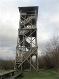 view gallery view gallery E11.1 km E11.1 km
|  Aussichtsturm Ketelvierth, SH, Germany Aussichtsturm Ketelvierth, SH, Germany
in Look-Out Towers [DE]Der Aussichtsturm Ketelvierth ist ein 16,4 Meter hoher Aussichtsturm in der Gemeinde Großenaspe in Schleswig-Holstein.
[ENG]The observation tower Ketelvierth is a 16.4 meter high lookout tower in the community of Großenaspe in Schleswig-Holstein. posted by: EDTA location: Schleswig-Holstein, Germany date approved: 01/02/2018 last visited: 02/05/2023 |
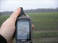 view gallery view galleryNE12.7 km |  N54 E10 - Neumünster (Germany) N54 E10 - Neumünster (Germany)
in Confluence Spots This confluence point is at the edge of a field south from Neumünster / Schleswig-Holstein / Germany. posted by: sorocos location: Schleswig-Holstein, Germany date approved: 02/08/2012 last visited: 12/31/2017 |
 view gallery view galleryNE13.2 km | Altona-Kieler Chaussee - Wittorf-Süd, Neumünster, SH, Germany in Milestones [DE] Halbmeilenstein der "Altona-Kiel Chaussee" bei Wittorf. [ENG] Semi milestone of "Altona-Kiel Chaussee" near Wittorf. posted by: EDTA location: Schleswig-Holstein, Germany date approved: 03/11/2016 last visited: 06/29/2017 |
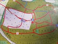
 view gallery view gallery N13.2 km N13.2 km
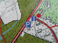
| Naturschutz und Erholung in Aukrug - SH, Germany in 'You Are Here' Maps [DE] eine Karte mit dem eigenen Standort am Parkplatz am Naturschutzgebiet in Aukrug [ENG] a map with the own location at the parking area at the nature reserve in Aukrug posted by: EDTA location: Schleswig-Holstein, Germany date approved: 04/18/2016 last visited: 05/14/2018 |
 view gallery view galleryN13.2 km | Naturpark Aukrug - SH, Germany in 'You Are Here' Maps [DE] eine Karte mit dem eigenen Standort am Parkplatz am Naturpark in Aukrug [ENG] a map with the own location at the parking area at the nature park in Aukrug posted by: EDTA location: Schleswig-Holstein, Germany date approved: 02/25/2018 last visited: 11/07/2020 |
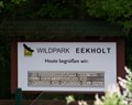 view gallery view galleryE13.4 km |  Wildpark Eekholt Wildpark Eekholt
in Zoos Seit seiner Gründung im Jahre 1970 durch Dr. h.c. Hans-Heinrich Hatlapa (verstorben 2009) und seiner Ehefrau Theda Hatlapa wurde der Wildpark kontinuierlich zu einer Naturerlebnis- und Bildungsstätte weiterentwickelt. posted by: Sebi Neumi location: Schleswig-Holstein, Germany date approved: 04/02/2013 last visited: 05/20/2012 |
 view gallery view galleryNE13.4 km | Halboffene Weidelanschaft - SH, Germany in 'You Are Here' Maps [DE] Eine Karte mit dem eigenen Standort an einem Aussichtspunkt am "Ochsenweg"
[ENG] A map with the own location at a viewpoint at "Oxenweg" posted by: EDTA location: Schleswig-Holstein, Germany date approved: 03/26/2016 last visited: 06/29/2017 |
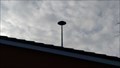 view gallery view gallerySE13.5 km |  Sirene FF Hasenmoor - Hasenmoor, S-H, Deutschland Sirene FF Hasenmoor - Hasenmoor, S-H, Deutschland
in Outdoor Warning Sirens Warnsirene auf dem Dach der Freiwilligen Feuerwehr Hasenmoor posted by: Windschattenwanderer location: Schleswig-Holstein, Germany date approved: 03/20/2018 last visited: never |
 view gallery view gallerySE13.5 km | Freiwillige Feuerwehr Hasenmoor in Firehouses Gerätehaus der FF Hasenmoor posted by: Windschattenwanderer location: Schleswig-Holstein, Germany date approved: 03/04/2018 last visited: never |
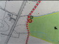
 view gallery view galleryN14.2 km | Karte am Boxberg, SH, Germany in 'You Are Here' Maps [DE] Eine Karte mit dem eigenen Standort an einem Parkplatz am Boxberg. [ENG] A map with your own position at a parking area at "Boxberg". posted by: EDTA location: Schleswig-Holstein, Germany date approved: 10/13/2015 last visited: 05/14/2018 |
 view gallery view galleryNE14.3 km |  ALDI MARKT, Boostedt ALDI MARKT, Boostedt
in ALDI Stores Öffnungszeiten: Mo - Sa 08:00-20:00 Uhr So geschlossen posted by: Sebi Neumi location: Schleswig-Holstein, Germany date approved: 10/17/2013 last visited: 03/08/2016 |
 view gallery view galleryNE14.3 km | Nordic Walking-Parcours Wittorf - SH, Germany in 'You Are Here' Maps [DE] Eine Karte mit dem eigenen Standort am Nordic Walking-Parcour in Neumünster-Wittorf. [ENG] A map with your own position at the Nordic Walking obstacle course in Neumünster-Wittorf. posted by: EDTA location: Schleswig-Holstein, Germany date approved: 03/26/2016 last visited: 07/11/2016 |
 view gallery view galleryE14.5 km |  Flugplatz Hartenholm - Timm Thaler - Hasenmoor, S.-H., Deutschland Flugplatz Hartenholm - Timm Thaler - Hasenmoor, S.-H., Deutschland
in Movie Locations Einige Flugplatzszenen aus der 1. Folge wurde auf dem Flugplatz Hartenholm in Hasenmoor gedreht. posted by: Windschattenwanderer location: Schleswig-Holstein, Germany date approved: 03/04/2018 last visited: never |
 view gallery view galleryE14.5 km |  Das Werner-Rennen - Hasenmoor, S.-H., Deutschland Das Werner-Rennen - Hasenmoor, S.-H., Deutschland
in Wikipedia Entries Wikipediaeintrag über das Werner-Rennen zwischen dem Comicautoren Rötger „Brösel“ Feldmann und dem Kieler Gastwirt Holger „Holgi“ Henze auf dem Flugplatz Hartenholm. posted by: Windschattenwanderer location: Schleswig-Holstein, Germany date approved: 03/01/2018 last visited: never |
 view gallery view galleryN14.6 km | Karte am Boxberg, SH, Germany in 'You Are Here' Maps [DE] Eine Karte mit dem eigenen Standort an einem Parkplatz am Boxberg. [ENG] A map with your own position at a parking area at "Boxberg". posted by: EDTA location: Schleswig-Holstein, Germany date approved: 10/13/2015 last visited: 08/22/2018 |
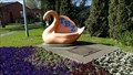 view gallery view galleryNE14.6 km |  Schwanenbank TBZ Schwanenbank TBZ
in Artistic Seating Hier könnte es sich um Objekt 19 handeln, er wäre dann aber umgestaltet worden.
Bunte Pracht
Aktionspartner: Lichtblick-Verein für Körper- und
Mehrfachbehinderte Neumünster e.V.
Gestaltung: »Lichtblick«-Kinder und Dorothea Schadow posted by: Sebi Neumi location: Schleswig-Holstein, Germany date approved: 06/23/2022 last visited: 08/20/2022 |
 view gallery view gallery NW14.8 km NW14.8 km
| Karte am höchsten Punkt des Boxberges, SH, Germany in 'You Are Here' Maps [DE] Eine Karte mit dem eigenen Standort an einem Parkplatz am Boxberg. [ENG] A map with your own position at a parking area at "Boxberg". posted by: EDTA location: Schleswig-Holstein, Germany date approved: 10/13/2015 last visited: 08/22/2018 |
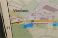 view gallery view galleryNE15.1 km | Karte an der Wasbecker Straße am Ortseingagn NMS, SH, Germany in 'You Are Here' Maps [DE] Eine Karte mit dem eigenen Standort an einer kleinen Parkbucht am Ortseingang von Neumünster.
[ENG] A map with the own location at a small parking bay on the outskirts of Neumünster. posted by: EDTA location: Schleswig-Holstein, Germany date approved: 11/02/2015 last visited: 12/16/2016 |
 view gallery view galleryNW15.1 km | Karte am Boxberg, SH, Germany in 'You Are Here' Maps [DE] Eine Karte mit dem eigenen Standort an einem Parkplatz am Boxberg. [ENG] A map with your own position at a parking area at "Boxberg". posted by: EDTA location: Schleswig-Holstein, Germany date approved: 10/13/2015 last visited: 08/22/2018 |
 view gallery view galleryNE15.3 km | Burger King - Wasbeker Straße - Neumünster, Germany in Burger King Restaurants Ein Burger King Drive In neben dem Freesen Center
Wasbeker Straße 346, 24537 Neumünster ? posted by: Sebi Neumi location: Schleswig-Holstein, Germany date approved: 10/26/2013 last visited: 09/30/2015 |
|